Agriculture and Settlement
in Medieval and Early Modern Zealand
A historical-geographical survey of Danish agriculture
and settlement conditions, c.1000-1688
Master’s
thesis by Johnny Grandjean Gøgsig Jakobsen
Institute of Geography
Roskilde
University 2004
Supervisor:
Jesper Brandt
Abbreviated
edition in English 2005
Introduction and summary
This is an
abbreviated edition in English of my master’s thesis presented to and approved by
the Institute of Geography at Roskilde University in the summer of 2004.
The main
goal of the present master’s thesis is to produce new knowledge on the
development of agriculture and settlement structure in Denmark during the
period c.1000-1688. Studies of historical geography in Denmark earlier
than 1688 are traditionally based upon retrospective use of the national Land
Register of 1688. In my paper, I try to show that such retrospective studies
for an average Danish region can be supplemented by several earlier sources of
various kind, which used with an understanding of the nature of the data and
their problems, actually can contribute intensively to our understanding of the
agricultural and settlement conditions in medieval Denmark. A basic part of my
report is therefore to present the potential data sources and evaluate their
usefulness for historical-geographical studies, including a presentation of old
and new methods to analyse the data. My historical sources can be grouped in
four classes. 1. Place-name types of the settlements; 2. Written economical
registers of parishes or villages; 3. Church buildings; 4. Structures of
parishes and village land units (vills). The presented data sources and methods
have been tested on a case study area of NW-Zealand, where it has been my aim
to describe the demographical, economical and agricultural situation at
different times in the period. In the analyses, the mentioned data has also
been compared to the natural-geographical conditions of the studied region. For
this purpose, I have pointed out twelve land-type areas with different but
representative soil and terrain types.
The
analyses begin with the land registers of the seventeenth century, where I have
combined the data of the two registers (1662 and 1688) with the reconstructed
areas of the vills (ejerlav) to calculate various relations, analyse the
regional distribution of these relations and evaluate their differences between
the twelve chosen land-type areas. By doing this, it has been possible to identify
areas of different degrees of cultivation, seed density, crop mix, orientation
of production (cattle versus grain), and land value. In the following chapters,
I have tested earlier sources such as place-name distribution, size of the
church buildings, parish structure and settlement pattern within the parishes,
and a set of taxations recorded in the Roll of the Bishop of Roskilde (c.1300).
In my
analyses, I have looked with special interest on the ‘thorpe-foundation’, that
is the foundation of a vast number of new settlements mainly dated to the high
medieval period, primarily with the place-name suffix -thorp, but in
this study also with other suffixes such as -tved and -rød. It is
quite clear, that in NW-Zealand the term thorpe has both been used on hamlets
founded close to the old villages (adelbyer) on their land, and on new
settlements in hitherto uncultivated wasteland. Also, it is possible to follow,
how some districts developed more thorpes than others. Differences in soil and
terrain, and related differences in production, can explain some of the
variations, but as areas with apparently similar conditions would end up with
quite different numbers of thorpes, also the aspect of time and perhaps
lordship has been suggested as possible influences. Especially in the
woodlands, some thorpes have been deserted in the Late Middle Ages, but it has
been quite difficult to find any signs of a general ‘Late Medieval Crisis’. On
the contrary, several areas within the region show signs of economical and demographical
growth during this latter part of the studied period.
Related to
this, I have tried to find any correlation between settlement structure and
agricultural production on the one side, and natural conditions such as soil
types and terrain on the other - also in order to see, if it is possible to
identify a general change in the perception of land value. From beginning to
end, it was the soils formed on moraine clay that held the highest evaluation,
with only small internal variations regarding the exact texture (light, medium
or heavy clay). Much more secondary was land (of all soil types) in hilly
terrain, and land dominated by sandy soils or wetland. It seems, however, as if
all the ‘secondary land types’ increased in relative value during the Late
Middle Ages and early Modern Ages, which can be explained by an increased
importance of both rye (sandy soils) and cattle (wetlands), and more clearing
of forest (hilly terrain).
Contents:
1. Tradition of historical geography in Southern Scandinavia
2. Presentation of the studied region : North-Western Zealand
3. Agriculture in seventeenth-century NW-Zealand
4. Settlement in medieval and early modern NW-Zealand
5. Churches and parish structures in medieval NW-Zealand
6. Medieval economy in NW-Zealand : ‘Episcopal taxation’
1.
Tradition of historical geography in Southern Scandinavia
The study
of historical geography in Europe regarding medieval agriculture and settlement
structure has often taken quite different forms reflecting the source situation
of each country. In Scandinavia, extant written material from the High Middle
Ages is rather scarce. This is especially evident on matters concerning
historical geography. Therefore, alternative methods have been developed to an
extent that might put us ahead of countries blessed with a richer textual
tradition. In the historical-geographical area, archaeology and place-name
studies can be pointed to as ‘Scandinavian specialities’.
But also on
a Scandinavian level, the medieval source situation differs among the countries,
resulting in different orientations of the national schools. The scarcity of
written material is, for instance, more distinct in Sweden than it is in
Denmark, but then the Swedes are in possession of an enviable amount of
numerous and detailed cadastral maps from the seventeenth century, where the
oldest mapping of Denmark of a similar quality is about 100 to 150 years later.
Logically, this has resulted in a historical-geographical tradition in Sweden
based upon the use of these maps, which for medieval studies have found use in
a retrospective way. However, it is also possible to identify a more general
tendency in Swedish historical geography towards a ‘cartographical thinking’
than what you will find in Denmark. Studies of medieval church building can be
used as an example. In Denmark, most of the medieval churches are preserved,
usually without any major exterior changes since the late sixteenth century.
Danish church-historical scholars have therefore based their studies and
theories on the physical church buildings and the variations of these, which
combined with sociohistorical speculations has led to a lasting dispute on the
question: Who built the churches - landlords or (groups of) peasants? In
Sweden, the number of preserved medieval churches is considerable smaller than
in Denmark, so instead, scholars here - traditionally based in cartography -
have looked into parish structures and their possible developing. Of course,
both questions have also been taken up by scholars in the respective neighbouring
countries, but never with same intensity, and often with a twist towards their
own ‘national school’: In Denmark, the physical size and shape of the churches
have been used to determine their place in the parish formation; in Sweden, the
seventeenth-century cadastral maps are used to determine whether churches were
built on demesnes land or common village land. Just as a number of Swedish
retrospective-medieval studies are based on cadastral maps of the seventeenth
century, retrospective studies of Danish medieval geography and society are
traditionally based on seventeenth-century Land Registers (see chapter 3).
The
starting point of historical-geographical tradition in Denmark was the study of
place-names, where linguistic elements in settlement names according to
place-name scholars can be dated to different periods. Some of the pioneers in
place-name-based historical geography in Denmark are Johannes Steenstrup
(1894-95) and H.V. Clausen (1916), who were able to identify systematic
differences in size (both physical and economical) and geographical
distribution of villages with different place-name suffixes. This was used to
advance theories on differences in age and reason for foundation of settlements
with different name-types, and ever since, place-name material has been a
traditional part of Danish settlement studies concerning Iron Age, Viking Age,
and the Middle Ages (the principles are used in this survey in chapter 4).
Another
important aspect in early South Scandinavian settlement-historical geography
has been the strikingly regulated ground-plan of many villages and fields, as
they are known from late-eighteenth- and early-nineteenth-century cadastral
maps (Lauridsen 1896). The original inspiration came of course from people
abroad like August Meitzen, but in Sweden and Denmark it was soon argued that
village- and field structures depicted on early modern maps probably could not
be attributed further back than the late High Middle Ages (Larsen 1918,
Lindgren 1939). Indeed, several studies have indicated an extensive settlement
reform in the fourteenth century. The physical structure of villages also
became the main focus of one of the leading historical geographers of Denmark,
Frits Hastrup (1964), who classified all Danish villages by their form and
internal structure, and based on this he propounded the thesis that medieval
villages were subjects to a most consistent spatial regulation, as the breadth
of the toft (that enclosed the individual farm within the village site) quite
accurately should reflect the farm’s share of the village field, and thereby
also its basis of assessment.
Next to
place-name studies, archaeology has made up one of the most important
cornerstones in South Scandinavian settlement-geographical history, as
archaeology at a very early time (mid-nineteenth century) was commonly
integrated with other disciplines related to landscape and settlement studies,
such as history, human geography, and physical geography. Among Danish pioneers
was archaeologist Sophus Müller (1904), who studied the connection between
ancient road systems, landscape topography, and burial mounds. The works and
ideas of Müller were continued by Vilhelm la Cour (1927) and Therkel Mathiassen
(e.g. 1959) with studies in a large regional scale, while Gudmund Hatt (e.g.
1938) performed an impressive series of thorough point-studies. All of them
agreed that settlement-historical development derived from natural conditions
in the physical geography, and - closely related to this - from agronomics. In
recent years, point-studies have dominated Danish settlement archaeology of
which the most famous example is the excavation of the Jutland village Vorbasse
(Hvass 1984), where it has been established, how the actual site of the
settlement has moved several times within a limited area up through the Iron
Age to the early High Middle Ages. In the 1970s, Erland Porsmose (1977, 1979)
and Torben Grøngaard Jeppesen (1979) conducted a series of settlement-historical
studies of villages on the island of Funen, in which archaeology took a leading
rôle. The Funen project supported the picture from Vorbasse of a break in
settlement continuity around the transition from Viking Age to early High
Middle Ages (i.e. 1000-1100).
The
agricultural side of Danish medieval-historical geography was at an early stage
taken up in a broad, synthesizing form by historians Kristian Erslev (1898),
Erik Arup (1925), and Aksel E. Christensen (1938), after which the discipline
was characterized by the publication of several extensive and informative
sources. A such with great importance for subsequent Danish studies in
historical settlement and agriculture is a collection of tables edited by
Henrik Pedersen (1928), presenting the main economical data of the Land
Register of 1688 (on the level of vills, parishes, and hundreds); both the
source and the data is further described (and used) in chapter 3. Among the
most important Danish medieval source publications is the Roll of King
Valdemar II (mid-thirteenth century), which was published, translated, and
extensively commentated by Svend Aakjær in three comprehensive volumes in
1926-43. Among other things, the roll contains a unique and most informative
taxation list for the villages on the island of Falster (situated south of
Zealand) c.1250-60. For the studies of medieval-historical geography on
Zealand, a highly valuable source is the Roll of the Bishop of Roskilde
(c.1370), published in 1956 by C.A. Christensen; the source is presented
and used in this survey’s chapter 6. Furthermore, a number of various less
extensive rolls and registers from the mid- and late-sixteenth centuries, not
least from Zealand, have been published, but perhaps due to their more regional
character, they have never received the same attention as the three
first-mentioned. The named publishers were, by the way, also the leading
scholars of contemporary agricultural-historical studies and debate in Denmark.
The
regional perspective in historical geography was quite early introduced in
Southern Scandinavia, especially among Scanian scholars (: Scania is the
southernmost part of Sweden, and was until 1658 a part of Denmark; both as a
Danish and a Swedish province, Scania has always held a special, regional
identity). Based on material from the eighteenth century, Åke Campbell (1928)
divided the province into three cultural-geographical types of regions called bygder:
plain-bygd (characterized by nucleated villages, open-field systems, and arable
production); wood-bygd (small, dispersed settlements, mainly based on pastural
production); and coppice-bygder (a combination of the two former types). In
1942, this was followed up and improved by a now classical doctor’s thesis of
Sven Dahl on settlement conditions and historical agronomics in Scania from the
sixteenth to the nineteenth century, in which he also included
natural-geographical conditions. Regional geography has a long and strong
tradition in Sweden, where among others Gunnar Lindgren (1939) at an early
point founded a school with his agricultural-historical studies of Falbygden in
Western Götaland. After World War II, the interest for regional-historical
geography also reached Denmark, e.g. with the studies by Ole Widding (1948) of
different types of field-systems on the island of Lolland. Local-scaled studies
of great regional value were performed by Carl Rise Hansen and Axel Steensberg
of field-systems in several Zealand villages (e.g. Hansen & Steensberg
1951, Steensberg 1968, 1974).
In the
second half of the twentieth century, Danish historical geography has produced
several thematical works on various topics within the discipline. Poul Meyer
(1949) gave a thorough account for historical settlement and agricultural
conditions, as these are reflected in preserved rules from old Danish village
regulations. A legal-historical perspective, which Annette Hoff (1997) has
followed up on with a fruitful use of Danish medieval law material. Erik Ulsig
(1968) has given a detailed account for medieval property structures, especially
on Zealand, a theme which in these years have been - and still are - object of
great attention among Danish scholars; an example of this is Carsten Porskrog
Rasmussen’s (2003) work on types of manorial structures in early modern
Schleswig. A more technical theme has been exhaustively tested and analysed by
Gritt Lerche (1994), and thereby generated remarkable new knowledge on
development and usage of the plough from ancient times till today. Another
thematical expert in recent historical geography in Denmark is Bo Fritzbøger
(e.g. 1992), who has specialized in forest history.
The vast of
majority of the scholars mentioned above are historians. The ‘grand ole men’
among geographers in Danish historical geography are the already mentioned
Frits Hastrup together with Viggo Hansen. Hansen (1964) conducted a regional
analysis of the connection between the development of settlement structure
(mainly based on place-name material) and natural conditions in Vendsyssel,
Northern Jutland. Scholarly attention was especially given to his including of
physical distance as an explanatory parameter in settlement geography, both
locally and for the structure of the individual vill. In consonance with old
masters like Ricardo and von Thünen, Hansen (1977) pointed to distance between
place of production and place of sale as a most influential factor in the
growing market economy of the Middle Ages. Inspired by Michael Chisholm (1962)
in England, Hansen (1973) too claimed he could find evidence in Denmark for the
thesis that the strips of village-field closest to the settlement site
generally were higher assessed than others, which he explained by a more
intensive tillage of the inner field area in form of manuring, marling, summer
ploughing, etc. Based on these studies and theses, he estimated a
general boundary between the intensively cultivated infield and the more
extensively used outfield to set in at about 800-1000 metres from the village
site. In a sense, these two leaders of historical geography within Danish
geography did each represent one of the two schools of the contemporary shift
in international historical geography: while Frits Hastrup employed a rather
static-retrospective view and method in his settlement-structural studies,
Viggo Hansen’s ideas and interpretations were highly based on the new thoughts
in historical geography of constant dynamics. Whereas Hansen therefore perhaps
is to be considered the most progressive of the two, Hastrup succeeded in
creating the settings for an actual historical-geographical environment at
Århus University during the 1970s together with American Robert M. Newcomb
(1970, 1975, 1979), where the latter among other things should be credited for
his work for the introduction of new methods and statistical tests in Danish
historical geography.
In post-war
Sweden as a whole (i.e. besides the province of Scania), the leading
personality in historical geography was David Hannerberg (e.g. 1955, 1971), who
developed a series of metrological methods for the study of past settlements
and agriculture on a micro level, something which was to have a huge impact on
future orientation in Swedish historical geography. Historical geography in
Sweden also became quite inspired by the new ‘topographical-genetic’ school of
German historical geography with its Siedlungsarchäologie, and during the 1950-60s emerged a strong
Swedish tradition for interdisciplinary projects between archaeology and
geography, especially in Stockholm and Lund, involving geographers like Sölve
Göransson and Staffan Helmfrid (1962). At first, the interdisciplinarity was
mainly individual, and so a matter of one person involving several disciplines
in his or her analyses. One of the first examples of interdisciplinary
historical geography in Southern Scandinavia involving two or more scholars
from different disciplines was implemented in Eastern Götaland in the 1960s,
and from the mid-1970s, this idea has been followed up by several major
interdisciplinary projects. The perhaps most famous and ambitious of these is
the Scanian Ystad Project, commenced in 1979 as a joined project among
three faculties at Lund University. The Ystad Project has generated a series of
publications since the late 1980s, with a main publication in 1991 (Berglund
1991), where a row of both experienced and young scholars based on extensive
studies have succeeded in giving a detailed, broad covering, and synthesizing
presentation of the historical-geographical development in Southern Scania from
the stone age till modern times. In the same period, Danish scholars were
involved in the big Pan-Scandinavian Ødegårdsprojekt, with focus on
traces and consequences in Scandinavian settlement structure of the - at that
time highly debated - ‘Late Medieval Crisis’. In Denmark, the project resulted
in two very informative and inspiring surveys from Hornsherred in Zealand
(Gissel 1977) and the island Falster (Gissel 1989), which both - in spite of
the name and original idea of the overall project - go far beyond just dealing
with derelict farms.
Altogether,
the 1970s classify as the grand decennium of historical geography in Southern
Scandinavia. The discipline has never since held a similarly visible rôle in
Danish research and education of students, where the historical-geographical
tradition for the last generation has been carried on by individuals. As
leading Danish personalities of the discipline in recent years, Erland Porsmose
and Karl-Erik Frandsen stand out. Through a long series of publications, the
archaeologically trained historian Erland Porsmose (e.g. 1977, 1979, 1981,
1987, 1988) has presented an exhaustive overall analysis of settlement and
agricultural development on the island of Funen from the Viking Age to the
seventeenth century, which can be considered the backbone of today’s knowledge
and understanding on rural Denmark in this period. In 1983-84, Karl-Erik
Frandsen (historian and geographer) performed two ‘neo-classical’ atlases on
the distribution of various types of field-systems in seventeenth-century
Denmark, and retrogressive mappings of regional settlement structures, with the
exact vill- and parish organization for the entire country in 1682-83 and c.1820.
Today, it
is fair to speak of a growing renaissance for historical geography in Denmark,
even though the term itself is rarely used. Several scholars from all of the
potentially related disciplines have for the last 10-15 years generated an
extensive amount of transdisciplinary studies within the
historical-geographical boundaries. An attemptive status of current
Danish historical geography - which far from claims to be complete - could be
listed up as follows. One of the few scholars in Denmark, who actually terms
himself a ‘historical geographer’, is human geographer Jørgen Rydén Rømer (e.g.
1976, 2000), who has performed a number of thorough analyses of agricultural
and settlement conditions in Jutland in the 1680s, while historical geography
of the Faroe Islands is almost synonymous with geographer Rolf Guttesen (e.g.
1992, 1996, 2004). Also, several geologists have recently joined the
interdisciplinary field, such as Niels Schrøder (2004), Kristian Dalsgaard
(e.g. 1984, 2001), and Mogens Greve (2000); the latter by developing a
G.I.S.-model for identifying hidden settlement sites from soil data and a
taxation list from 1844. Obvious interdisciplinary partners for the geologists
are the archaeologists, where especially Jens Andresen (e.g. 2004), Charlotte
Fabech and Jytte Ringtved (2002) have shown great interest in working with
scholars, methods, and data from other disciplines. One archaeologist, Helge
Nielsen (1979, 2002), even has left the trowel in favour of digging into the
written sources of medieval agronomics.
In Denmark,
the interdisciplinary field of historical geography has traditionally enjoyed
many fruitful visits from historians, and fortunately, this is still the case.
Fine examples of this are the agricultural and economical-historical studies of
especially Southern Jutland performed by Bjørn Poulsen (e.g. 1997, 2003, 2004),
and Per Grau Møller’s studies of extant relicts of medieval high-backed ridges
(1995) and the development of settlement in different types of landscapes on
Funen (2000). In the latest years, tireless Erik Ulsig (2001, 2004) has
continued his exhaustive studies of the correlation of late medieval plague and
agricultural crisis on the one side with contemporary changes in size of
population and land prices on the other. Peter Korsgaard has not only performed
interesting analyses based on historical maps on his own (e.g. 1988, 1995), he
has also put a great effort in teaching others about the possibilities - and
pitfalls - of working with old maps in historical geography (e.g. 2004).
Finally, church archaeologists Ebbe Nyborg (1979, 1986) and Jes Wienberg (1993)
have compared medieval church building with contemporary demography, economy,
and sociohistorical conditions.
Scanian
tradition for historical geography has in recent years been continued by human
geographer Mats Riddersporre (e.g. 1995) and his studies of the province’s historical
settlement and agriculture, while archaeologist Mats Anglert (e.g. 1995, 2003)
through the use of various quantitative methods has presented interesting new
theses on Scanian church building and parish organization. Both scholars
originate from the interdisciplinary environment at Lund University at the time
of the Ystad Project. The main caretaker of historical geography at Lund
University today is human geographer Tomas Germundsson, whom together with
Peter Schlyter have produced an Atlas of Scania (1999), a very fine
example of a modern historical-geographical atlas. The leading centre of
historical geography in Scandinavia today is, however, situated further north
in Stockholm University, where the Institute of Human Geography houses an
actual department or centre for Historical Geography and Landscape Studies.
Among the many capacities related to this centre, one could mention Mats
Widgren (e.g. 1997, 2003), Ulf Sporrong (e.g. 1998), Ulf Jansson (e.g. 1998),
Kristina Franzén (e.g. 2002), and Johan Berg (e.g. 2003). Located not far from
Stockholm, Janken Myrdal (e.g. 1985, 1991, 1999) of the University of
Agriculture in Uppsala is one of the leading scholars in agricultural history
of medieval and early modern Sweden. In recent years, a promising
interdisciplinary centre for agricultural history has been started in Uppsala
by Myrdal together with historical geographer Clas Tollin (e.g. 1999) and a
crew of talented PhD-students.
In Denmark,
the last 10 years has been characterized by a number of interdisciplinary
research projects and symposia within the area of historical geography, often
with development of the cultural landscape over time as the overall theme (e.g.
Etting 1995, Fabech & Ringtved 1999, Dalsgaard & al. 2000, Møller &
al. 2002). In this context, a special mentioning should be attributed Per Grau
Møller for his great participation in several of the projects, seminars, and
other initiatives, which for the last decennium have laid the scene for
historical geography in Denmark
Even though
historical geography neither institutionally nor as an applied term holds the
visible position, which it had in the 1970s, its basic interdisciplinary idea
is still very much alive among scholars in present-day Denmark. A promising
sign of this is a fine string of on-going or recently finished PhD-theses from
various disciplines. As examples can be pointed to the study of Danish ‘polder
history’ by geographer Morten Stenak (2005), and the work of pollen analyst
Anne Birgitte Nielsen (2003) on G.I.S.-modelled mapping of vegetational
land-cover development based on pollen analyses, while the on-going studies
include historians Adam Schacke and Peder Dam (both on manorial organization in
early modern Denmark), place-name scholar Birgit Eggert (on distribution of
Danish holt-settlements), and archaeologist Mette Busch (on medieval and
early modern landscape development in coastal areas). Thus, not only in Sweden
but in Denmark too, the future of historical geography - at least by doing, if
not by name - looks confident for at least one more generation.
2. Presentation
of the studied region : North-Western Zealand
Object of
the present series of historical-geographical analyses is the north-western part
of Zealand, which is the biggest of the Danish isles (figure 2.1). Basically,
the region has been selected because it is of a suitable size for the
analytical purpose, and it offers a cultural and physical geography which can
be regarded as representative for a great part of Eastern Denmark. Still, in
matters of historical geography, it has - until now - been a rather overlooked
region. And finally, it is my personal home region, which gives me a natural
advantage in form of a local insight that I could never achieve for other
regions in the available time given for a master’s thesis.
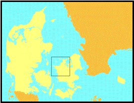
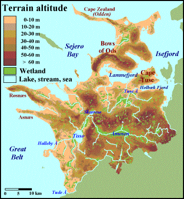
Figure
2.1. Overview map of NW-Zealand with boundaries of the included hundreds, and
medieval towns in- and outside the region. The inserted small map of Denmark in
the upper right corner shows the location of the analysed region.
The region
of North-Western Zealand (henceforth: ‘NW-Zealand’) is arbitrary in the sense
that it cannot claim any physical-geographical or historical identity, which
differentiates it from the adjoining parts of Zealand. For a large part it is
separated, though, from the neighbouring districts by two major streams, Tude Å
to the south and Elverdams Å to the east, together with the inlet Isefjord in
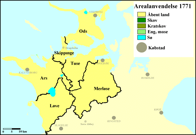
the north-east (figure 2.2). Furthermore, the region consists of six medieval
‘hundreds’ (Danish: herreder), administrative and juridical units, each
with their own local court (Danish: ting). The names of the hundreds in
NW-Zealand are Ods, Skippinge, Ars, Tuse, Løve, and Merløse, and even though the
hundred units themselves are of no importance in the performed analyses (where
the data will be analysed in geographical units of vills, parishes, and
specially defined ‘land-type areas’), their names will be used continuously
throughout the survey in order to help the reader orientate his or her way
around the regional descriptions. Also, the boundaries of the hundreds will
appear on most of the depicted maps.
My survey
of the historical geography of NW-Zealand is purely oriented on the rural
districts, where the only focus on the towns is in regard of their influence on
the rural hinterland. Indeed, NW-Zealand is primarily a rural region, as the
major historical cities of Zealand all were located in the east (the episcopal
seat and high medieval capital of Roskilde, the late medieval capital of
Copenhagen, and later on the important toll-city of Elsinore). In the
north-western region, we have three medieval towns with royal charters:
Kalundborg to the west, Holbæk to the east, and Nykøbing to the north. To the
immediate south of the region, the medieval town of Slagelse is located. While
Slagelse appears to be the oldest urban centre on Western Zealand, known as
such from the eleventh century, the oldest town within the north-western region
is Kalundborg, which grew up around the perhaps strongest high medieval
fortress of the country from the twelfth century; at first a privately owned
castle, but later to be a royal stronghold. A royal base of a more modest
nature was established in Holbæk in the thirteenth century, which soon became
the most important economical centre of the region. Youngest of the medieval
towns in NW-Zealand is Nykøbing, which did not begin to take form until the
Late Middle Ages, and still by the end of the studied period only was of
limited economical and demographical size. Probably far more important was the
episcopal castle of Dragsholm in Skippinge hundred, situated strategically on
the narrow isthmus connecting Ods hundred to the rest of Zealand. Dragsholm
Castle, dated to the early thirteenth century, was not only used as an
episcopal seat and military stronghold, it was also to be the centre of an
extensive manor, perhaps the most important of the episcopal estate on Zealand.
The major
late medieval landowner in NW-Zealand was the Bishop of Roskilde, together with
the canons of the Roskilde Chapter. Otherwise, most of the land was owned by
local magnates of only limited regional importance. In earlier times, where the
sources are scarce, various branches of the royal family and the powerful
magnates of the White family seem to have possessed a significant part of the
region, but through gifts and grants a great part of these estates came to the
Church, mainly represented by the episcopal seat in Roskilde. NW-Zealand is
unusual in the way that it has never housed a monastery. Estate wise, the
region was not without its monastic influence, though, as three major
monasteries were situated to the immediate south of the regional ‘boundary’, of
which especially the Cistercian abbey of Sorø, one of the greatest landowners
in medieval Denmark, held a lot of property in the southern and central parts
of the region. In 1536, the Lutheran king Frederik III announced the closing of
the Catholic Church in Denmark, and by doing this, all ecclesiastical estates
became royal property. Some of it was given back to the now Lutheran Church in
a more restricted way, while an other extensive part was given or exchanged to
the king’s supporters in the government, but in NW-Zealand, the majority of the
former episcopal land were allocated as entailed estates for the new royal
representatives, the lensmænd, who governed the region from the royal
castles in Kalundborg, Holbæk, and Dragsholm.
The net
spatial area (excl. medieval towns, major lakes, fiords, and areas drained in
modern times) of the analysed region is 1,664 km².
Physical geography of
NW-Zealand and identification of the land-type areas of the survey
During the
Ice Age, NW-Zealand was - as the rest of the area later known as Denmark -
overflowed by several glacial movements, and the entire region was covered by
the so-called ‘Late Baltic Iceflow’ at the end of the Weichselian Glaciation.
During the general retreat of the ice (10,000 BC), several smaller pushes forwards occurred,
which have resulted in a number of more or less distinct end-moraine lines in
the region. The most impressive of these are the ‘Bows of Ods hundred’ in the
northern part of the region, including the steep hills of Bjergene (‘The
Mountains’, no less) with the regional high point in Vejrhøj (‘Weather Hill’)
at 121 metres above sea level to the north-west of the glacial basin of
Lammefjord (figure 2.2). Otherwise, the geology of the region is characterized
by a fragmented mixture of stagnant-ice landscapes (hilly terrain with no
systematic orientation and with numerous wet hollows), moraine plains (flat or
slightly undulating landscape with loamy soils), and meltwater plains (quite
flat landscape with sandy soils).
Figure
2.2. Physical-geographical map of NW-Zealand (before the nineteenth-century
draining projects) with lakes, streams and wetland areas, as well as the most
important landscape names.
As seen on
the map in figure 2.2, the hilly terrain is prominent to the north of
Lammefjorden, north of Lake Skarresø, and in the central and eastern parts of
the region, while large coherent plains are found in the west, and south of the
fiords. South of Åmosen, a ‘highland plain’ is situated in conjunction with a
major plateau on the central Zealand. Hydrographically, the region is dominated
by the largest coherent wetland area on Zealand, Åmosen (‘The Moor along the
Stream’), which is geologically based on a glacial meltwater plain in the
south-central part of the region, with somewhat limited possibilities of
natural draining due to the surrounding terrain. The wetlands do have an outlet
through Halleby Å, the biggest stream of the region, which flows through the
lakes of Skarresø and Tissø before it reaches the sea in Great Belt. Especially
along the upper course of the stream, water has spread to the extensive meadows
of Åmosen. A smaller version of the same hydrography is found along Tuse Å with
an outlet in Holbæk Fjord south of Cape Tuse. Of general geographical interest
it could be noted that the greater part of the Lammefjord has been dammed and
drained in the nineteenth and twentieth centuries, which has added 55 km² of
dryland to the region; the most extensive damming and draining project in
Danish history.
Soil
conditions in NW-Zealand are, like the terrain, for a large part formed in the
latest Ice Age, where the entire region as mentioned was overflowed several
times by glaciers. Hence, the chief part of the region is covered by a moraine
bed of mixed debris material (till), which on Zealand consists of 5-25 per cent
clay, often of a quite calcareous content, which makes it well-suited for
arable agriculture. In addition, the region holds considerable areas of
meltwater sand, primarily as deposits on outwash plains, e.g. located on the
outer side of the Bows of Ods hundred, on the outer parts of capes Røsnæs and
Asnæs, and especially in the areas to the north and south of Åmosen. Of
postglacial deposits, the region is slightly marked by shifting sand along the
coastline of the Sejerø Bay and the north coast of Ods, but more importantly,
there are numerous and often quite considerable areas of freshwater deposits,
of which the most extensive are located in the region’s central part at Åmosen
and around the upper course of Tuse Å, together with several formations alongside
the major streams. In the hilly areas of terminal moraines, the soil is often
dominated by sand and gravel, while the stagnant-ice terrain with its mixture
of steep hills and ‘kettle holes’ often is characterized by moraine soils of
differing clay content.
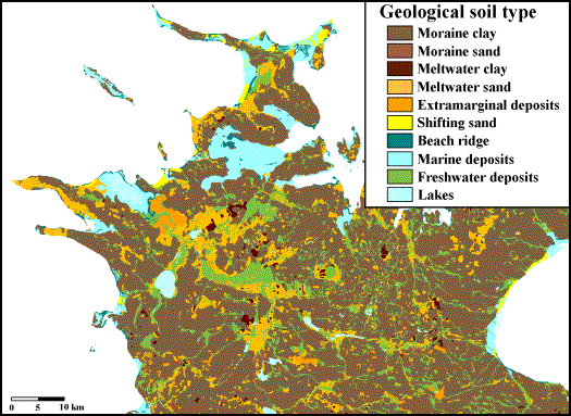
Figure
2.3. Geological soil map (1:200,000) for the north-western and central parts of
Zealand.
The
geological soil types are, so to speak, the parent material of which the top
soils of today have been generated. In Denmark, soil-type classifications have
been performed and mapped for both the geological soils and the top soils.
While focus of the first classification is on the origin of the soil, the
latter is only concerned with the present-day textural condition of the top
layer and the content of humus. Naturally, there is a considerable connection
between the geological parent soil and the upper soil type, so that meltwater
deposits mainly have produced sandy soil types (with small spots of very clayey
soils), the moraine bed has produced loamy soil types, and the freshwater
deposits in most cases have generated a humus soil. There are, however, also
important variations. This is especially evident in the moraine bed areas,
where we find three loamy soil types. Most common in NW-Zealand is the soil
type ‘loam’ (with the type code FK4), which can be described as a medium-clayey
loam. Elsewhere, especially in the western part of Ars, the moraine bed has
generated quite extensive areas of the heavier ‘clayey loam’ (FK5), while in
other places (such as west of Åmosen, in southern Ods, and at Cape Tuse), the
top soil has developed into a lighter ‘sandy loam’ (FK3L).
In order to
be able to evaluate any influence from the physical-geographical conditions on the
human-geographical development in NW-Zealand in the period 1000-1688, the
regional-comparative analyses will be supplemented with a comparative study of
twelve specially selected ‘land-type areas’ from the region (figure 2.4 and
table 2.1). Each land-type area is characterized by a rather homogeneous
physical geography in regard of terrain and soil conditions. Still, most of the
land-type areas will contain minor sub-areas of deviating soil types, and to
prevent these from disturbing the average values of the individual land-type
areas, only data from those of the vills or parishes within the area, which do
indeed comply with the selective specification of the land-type area in
question, will be included in the average calculation (e.g. at least 66 per cent
of the area within the vill/parish should be classified as soil type FK4).
Several of the selected land-type areas have identical physical-geographical
conditions (at least according to the selective specifications), and thereby it
will be possible to test, if land-type areas within such groups behave fairly
alike, or whether for example the location within the region appears to
influence. The twelve land-type areas are selected in such a way that all the
primary terrain- and soil types in NW-Zealand (and, hence, in Eastern Denmark
as general), are represented. As seen in figure 2.4, where the land-type areas
are depicted on a background of the (top-)soil-type distribution, the districts
north of Lammefjorden are not represented at all by the land-type areas, which
is due to the fact that the terrain- and soil conditions in Ods hundred are so
alternating and fragmented that it is almost impossible to find a potential
land-type area with homogeneous conditions of sufficient size.
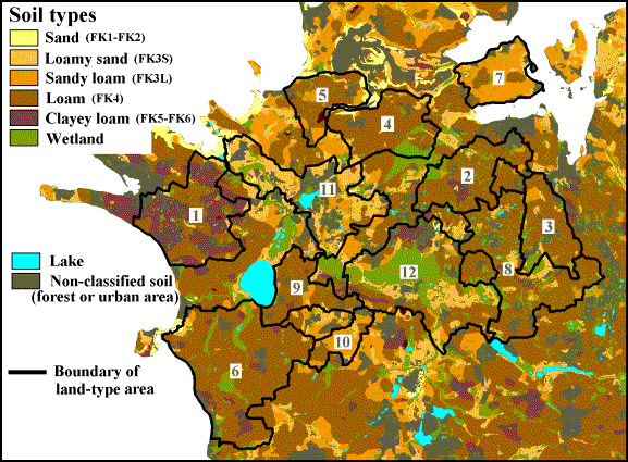
Figure
2.4. Map of soil types in NW-Zealand with focus on the twelve selected
land-type areas of the survey. The numbers relate to references in the text and
table 2.1. Note, that only analysed units (vills or parishes) within the area,
which do comply with the selective land-type-requirements of soil and terrain,
are included in the analyses.
Table
2.1. List and short description of the 12 selected land-type areas of
NW-Zealand.
|
Land-type area |
Physical- Terrain |
geographical characteristics Soil conditions Net area (ha) |
||
|
1 |
W-Ars |
Plain |
Moraine clay (till). At least 50% FK5. |
7,797 |
|
2 |
NW-Merløse |
Plain |
Moraine clay (till). At least 66% FK4. |
4,128 |
|
3 |
E-Merløse |
Plain |
Moraine clay (till). At least 66% FK4. |
2,745 |
|
4 |
N-Tuse |
Plain |
Moraine clay (till). At least 66% FK4. |
5,228 |
|
5 |
Skippinge |
Plain |
Moraine clay (till). At least 66% FK4. |
3,144 |
|
6 |
W-Løve |
Plain |
Moraine clay (till). At least 66% FK4. |
11,768 |
|
7 |
Cape Tuse |
Plain |
Moraine clay (till). At least 50% FK3L. |
3,881 |
|
8 |
SE-Merløse |
Hilly |
Moraine clay (till). At least 66% FK4. |
5,077 |
|
9 |
E-Løve |
Hilly |
Moraine clay (till). At least 66% FK4. |
3,352 |
|
10 |
E-Løve |
Hilly |
Moraine clay (till). At least 50% FK3L. |
1,559 |
|
11 |
Lake Skarresø |
Both plain and
hilly |
Meltwater sand. At least 50% FK3S. |
7,444 |
|
12 |
Åmosen |
Plain |
Freshwater deposits. At least 33% wetland. |
9,983 |
3. Agriculture
in seventeenth-century NW-Zealand
My analyses
begin with the traditional, retrospective starting point in Danish medieval
geography: the Land Registers of 1662 and 1688. Both land registers were
attempts of the state to come up with a fair taxation system for the entire
kingdom. The first register of 1662 was based on the rent rolls of the estates.
Annual sown acreage and rent, both divided in kinds of crops and rental
mixture, were recorded, and based on this, a taxation rate called hartkorn
was calculated for each farm. For instance, a farm paying an annual rent of 1
pound of barley, 1 pound of rye, 2 barrels and 4 bushels of oats, 1 lamb, 1
goose and 4 chickens, would, if the rent was found to correspond with the sown
acreage, be assessed to about 10 barrels of hartkorn. In 1688, this rent-based
land register was replaced by a new and quite ambitious registration, as every
single farm of the kingdom had its arable acreage (usually split up in numerous
furlongs) measured in actual size and evaluated for soil quality. Combined with
a more rough estimation (‘à l’advenant’) of the access to pastures and
meadows, a new taxation in barrels of hartkorn was carried out for each farm.
An average farm with 35 barrels of arable land (19.6 ha) of a normal soil
quality in NW-Zealand, would, for instance, be assessed to a taxation of about
7 barrels of hartkorn.
Extent of cultivation
(arable percentage 1688)
Based on
the two seventeenth-century land registers, I have tried to analyse the
contemporary perception of land value on different soil types and terrain types
in the region, together with variations in agricultural land use. First, I have
looked into the relative extent of cultivation around each village, by
comparing the sown acreage recorded in 1688 with the entire vill area (i.e.
arable land, pastures and meadows). In NW-Zealand, the average arable
percentage is found to 46 per cent, going from an average of 41 per cent in the
hundred of Merløse to 54 per cent in Skippinge. On the Danish Isles, which were
in general intensively cultivated in 1688, the arable land usually constituted
30-60 per cent of the vills. However, in many regions it is possible to find
areas of either a higher or a lower arable percentage. This is also the case in
NW-Zealand.
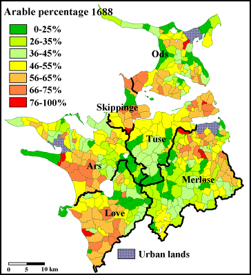
Figure 3.1.
Arable percentages in NW-Zealand 1688 calculated as the recorded sown acreage
as a percentage of the entire vill area. Urban lands are not included. The bold
lines represent boundaries of the medieval hundreds.
As shown in
figure 3.1, the highest arable percentages of the region can be found to the
south and north of the city of Holbæk, around the inner Lammefjord, and in the
western parts of Ars and Løve. In the central part of the region, however,
there is a huge area with relatively low arable percentages, which corresponds
nicely with the terrain map (figure 2.2), as this is an area of either hilly
terrain or widespread wetlands. Also the northern parts of Ods show a limited
cultivation; this can partly be explained by some of the poorest soils in the
region (very sandy).
By looking
at the twelve land-type areas of the survey, a rather distinct correlation
between physical geography and the extent of cultivation emerge (figure 3.2).
The primary factors of influence seem to be the subsoil (the parent deposit
material) and the terrain relief, whereas variations of texture in the top soil
show no importance. In all but one of the areas of plain moraine lands (the
seven top areas in the figure), the average arable percentages of the vills are
found to be as close as 59-61 per cent. For the sole exception, northern Tuse,
the average percentage is 50; neither the physical nor the cultural geography
offers any obvious explanation for this. In the three areas of hilly moraine
land, the average extent of cultivation is somewhat lower; 43-45 per cent on
loam, 32 per cent on sandy loam. Even if Denmark in general and the Danish
Isles in particular to the rest of the world will appear rather flat, the
terrain has proven its influence on historical geography in other studies also.
On the island of Funen, for instance, Per Grau Møller has found that in hilly
terrain, the arable percentages according to the 1688 land register were quite
low, no matter what the soil type (Møller 2000). Moving on to the sandy soils (formed
on glacial meltwater sand deposits) around Lake Skarresø, the vills in this
area show an arable percentage quite similar to vills of the hilly moraine
lands (39 per cent), whereas the wetland-dominated vills around Åmosen on
average only had cultivated 29 per cent of their land.
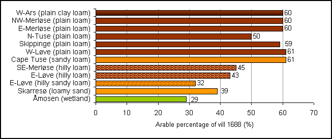
Figure 3.2. Average arable percentages in
twelve land-type areas of NW-Zealand in 1688.
Soil and
terrain alone, however, cannot explain all variations in the region. For example,
the coastal forelands to the west and north, and the northern side of the capes
in the Isefjord, had low arable percentages in 1688 regardless of the physical
geography. This could indicate, that a weatherly exposed position towards the sea did not inspire to an expanding
of the arable. In general, the low extent of cultivation in the coastal
forelands of NW-Zealand does not seem to be due to a remote location and hence
long transport distances to markets, as some of the less cultivated coastal areas
are actually found in the immediate neighbourhood of the cities Kalundborg and
Nykøbing. Still, the rather high arable percentages of Cape Tuse should perhaps
be seen as a result of its location close to the city of Holbæk.
Land value 1688
By comparing
individual vill areas and hartkorn taxations, it is possible to
calculate a relative expression for perceived land value as an average for the
entire vill in 1688. For instance, the vill of Søstrup (Merløse h.) has an area
of 321 barrels of land (180 ha) and it was assessed to a total of 45.2 barrels
of hartkorn in 1688. Thus, the average land-value rate of the vill is 7.1
barrels of land per barrel of hartkorn (bol/boh); the more barrels of land it
takes to equal one barrel of hartkorn, the lower was the perception of the
agricultural land value. Such an ‘area-proportional land-value rate’-method can
be criticised on several points, and for the individual vill, the method should
only be used with great caution. The potential of the method lies in the use on
a regional scale as in NW-Zealand, where all the land-value rates of the
individual vills within the region are considered as a whole (figure 3.3).
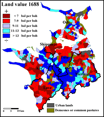
Figure
3.3. Perceived land value in NW-Zealand 1688 calculated as the entire vill area
(in barrels of land) compared to the total taxation of the vill (in barrels of
hartkorn); low land-value rates indicate a high area-proportional taxation.
Urban lands, demesnes and common pastures are not included. The bold lines
represent boundaries of the medieval hundreds.
The
land-value rates of NW-Zealand in 1688 show a rather polarized distribution.
The average rate of the region is 10.0 bol/boh, but the majority of the vills
have values of either less than 9.0 (high taxation) or more than 12.0 bol/boh
(low taxation). According to this analysis, good farm land in the year 1688
(that is with low land-value rates) was primarily widespread in the northern
and the eastern part of Merløse, in northern Tuse, and southern Skippinge, on
the south side of the two Isefjord capes in Ods, as well as in western Løve,
and south-western Ars. The poorest farm land according to the taxation was
concentrated to the central parts of the region, especially around Åmosen and
Lake Skarresø, and on the most exposed coastal forelands.
Just as the
arable percentages in NW-Zealand 1688 were found to correlate closely with the
physical geography, even more so do the vill-based area-proportional land-value
rates. Looking at the twelve land-type areas (figure 3.4), it is quite notable,
that all five areas of the medium-moraine-soil type (loam) in plain terrain
have area-proportional land-value averages inside an interval of 7.1-7.6
bol/boh. Within this interval, also the average land value of the vills on
plain clayey loam (western Ars) is situated, whereas the lighter moraine soils
(sandy loam) on Cape Tuse follow a step further down the land-value scale with
an average of 8.07 bol/boh. The next level is occupied by the two areas of
hilly loam (10-11 bol/boh), whereas the hilly sandy loam of eastern Løve on
average was valued as poorly as 14.66 bol/boh. Thus, both in plain and hilly
terrain, sandy loam was apparently considered less valuable as loam or clayey
loam in 1688; this difference is most evident in hilly terrain. Indeed, the
hilly sandy loam of NW-Zealand was on average valued as bad as the pure sand
soils around Lake Skarresø (14.78 bol/boh). At the bottom of the scale was -
once again - the group of vills around Åmosen, with an average land-value rate
as low as 17.26 bol/boh.
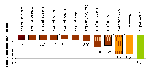
Figure
3.4. Average land-value rates in twelve land-type areas of NW-Zealand 1688. The
land value is expressed by an area-proportional rate of barrels of land per
barrels of hartkorn (bol/boh). Note, that the actual land value (taxation per
land unit) grows with falling land-value rate.
To sum up,
the conclusion from this analysis is that the perceived land value in
NW-Zealand 1688 differed significantly among moraine soils, sand soils and
wetland soils, as it took two barrels of sand-soil land to equal the economical
value of one barrel of moraine-soil land, whereas the wetland wills of Åmosen
had to come up with almost 2.3 barrels of land to match a barrel of moraine
land. On the moraine soils, the terrain played an important influence on the
relative land value, as moraine soil in hilly terrain was valued at c.70
per cent (loam) or 55 per cent (sandy loam) of similar soils in plain terrain.
A
comparison of figures 3.1 and 3.3 will show a similarity, which should not
surprise. Vills blessed with high-valued soils suited for cultivation were of
course more likely than others to claim a large portion of the vill area for
arable use - and vice versa. Alternatively, the appraisers have generally
assessed well-cultivated vills higher than they did the less-cultivated vills.
Among Danish agricultural-historical scholars, it is the general opinion, that
the Land Register of 1688 did in fact systematically underestimate
non-cultivated land compared to its actual economical potential, and hence, vills
primarily orientated on arable farming were unequally heavily taxed. This claim
will be tested later in the chapter. Until then, a closer look at figures 3.1
and 3.3 will show, that the distribution patterns are not completely identical.
For instance, the first analysis found almost the same arable percentages in
all areas on moraine soil in plain terrain, but the light sandy-loam soil of
Cape Tuse was valued distinctly lower than the others. One could say that the
farmers of Cape Tuse had cultivated the same relative amount of their vill land
as farmers on heavier moraine soils had, but apparently, the sandy-loam soil
did not yield quite the same per area unit. The same can be argued even more
for the sandy soils of the region, which in 1688 were not cultivated
considerably less than were the hilly moraine soils, but still they were
clearly considered less productive according to the land evaluation.
Similar
studies have recently been performed on a national scale by Peder Dam (2004), who
were able to find average land-value rates on the Danish Isles in the area of
10.6-11.1 bol/boh, which differed distinctly from the Jutland peninsula, where
the rates went from about 15 bol/boh in the most fertile regions to 50 bol/boh
in the West-Jutland moor areas. Indeed, the national differences in land values
correlate nicely with the geological division of Denmark in the
moraine-dominated isles in the east and the sandy soils of Jutland in the west.
However, Dam also found, that vills of identical soil types generally were
taxed significantly harder (and so valued higher) on the Isles than they were
in Jutland. Especially, the Zealand sand soils were rated remarkably high,
which were particularly evident in Eastern Zealand near the major cities. In
fact, on Zealand as a whole it was Dam’s conclusion, that terrain was more
influential on land-value rates than was the soil.
In England,
Bruce Campbell (2000) has used a related area-proportional method to establish
arable land value on fourteenth-century demesnes. His study would indicate,
that medieval land value on English demesnes was by large a product of three
factors: land-productivity value, access to manpower, and distance to (or
accessibility of) urban markets. Something similar is quite possible for
NW-Zealand, as there is a tendency of increasing arable percentages and land
value in the immediate neighbourhoods of the cities of Holbæk and Kalundborg,
and Dragsholm Castle, which cannot be explained by physical-geographical
conditions only. However, such relations have not been tested systematically in
the present analyses.
Crop mix 1662
The three major species of grain on
seventeenth-century Zealand were barley, rye and oats. In some districts, also
buckwheat and dredge (a mixture of barley and oats) held some importance. Wheat
had lost its position as primary bread grain in Scandinavian agriculture during
an unfavourable change of climate during the Iron Age, and still by the
seventeenth century, it did not appear in NW-Zealand rent rolls. Based upon the
information of the 1662-Land Register, it is possible to calculate the relative
crop-mix combination on the sown acreage of each farm. In figure 3.5-3.7, these
numbers have been summed up to parish level to give a clearer picture of the
intra-regional tendencies.
Barley was
the primary grain of the region at this time, as it was for most of the nation.
Not only was it used for malt and producing beer, it was also an important food
grain for both porridge and bread; since the Viking Age, it had been the
primary substitution for wheat. Thus, barley was grown in every parish of the
region (and with few exceptions in every vill), and to judge from accounts of
seed and rent, normally around half of the annually sown acreage was used for
barley; in most parishes, the barley share lies within 40 to 60 per cent
(figure 3.5).
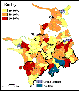
Figure
3.5-3.6. Average percentages of sown acreage used for barley (3.5) and rye
(3.6) in the rural parishes of NW-Zealand according to seed and rent data in
the Land Register of 1662. The bold lines represent boundaries of the medieval
hundreds.
Since
almost all arable land on seventeenth-century Zealand to some extent was used
for barley, it is perhaps more interesting to look at the distribution of the
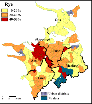
other main crops. The second most important crop was rye, which gained ground
during the Middle Ages as a better bread grain than barley. Even today, rye
bread is a basic part of Danish cuisine. As shown in figure 3.6, the
1662-distribution of rye in NW-Zealand is far more systematic than it is for
barley. In the eastern Ars, rye actually covered almost half of the sown
acreage. On a regional basis, rye constituted around 20 per cent of crop
production, and hence also the parishes around Åmosen, in Tuse, and
south-western Løve manifest themselves as rye-cultivators above average. Large
areas of limited rye-growing can be found in Merløse and especially in Ods.
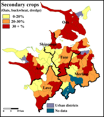
The part of
the arable land in NW-Zealand, which in 1662 was used for neither barley nor
rye, was primarily used for oats. Besides oats, buckwheat and dredge were grown
with varying weight around the region. All these secondary crops are known to
have been used for human food, but their main function on seventeenth-century
Zealand were as fodder, especially for horses. The average percentages of
arable land sown with secondary crops are shown in figure 3.7. There are some
variations in the type of fodder crops used in different parts of the region.
Oats had its main importance in eastern Løve, western Ars, and south-eastern Merløse.
In Ods, eastern Ars, Tuse, and western Merløse, growing of buckwheat is
recorded, while dredge primarily was grown in the hundreds of Ods and
Skippinge.
Figure
3.7. Average percentages of sown acreage used for secondary crops (oats,
buckwheat and dredge) in the rural parishes of NW-Zealand according to seed and
rent data in the Land Register of 1662. The bold lines represent boundaries of
the medieval hundreds.
Crop-mix
percentages for the 12 land-type areas of the region are calculated in figure
3.8. In the vills on the plain moraine soils, usually around half the arable
acreage was sown with barley. In the areas of hilly moraine, the percentage of
barley was generally higher than it was for parishes on the plain moraine
(around 60 per cent). The barley percentages should for a large part be read in
coherence with the alternatives. This will show that variations in barley
percentages are followed by almost similar counter-variations in rye
percentages. In most areas with plain moraine soil, 20 to 25 per cent of the
arable land was used for rye, while in the hilly moraine areas, rye average was
down to around 11 per cent.
While the
fluctuations of barley and rye almost counterbalanced each other, the average
relative share of arable land used for secondary crops kept surprisingly stable
(26 to 31 per cent) in almost every area of moraine soil, no matter what the
specific texture type or terrain. The main exception is found in Løve, where
the barley-dominated western part only had a 22 per cent share of the arable
used for oats, while the sandy loam soils in the hilly land of south-eastern
Løve saw an oats percentage of no less than 35. Most likely, farmers of the
Løve ‘highland’ have sold a fair part of their oats production to the
barley-growing farmers down on the plains.
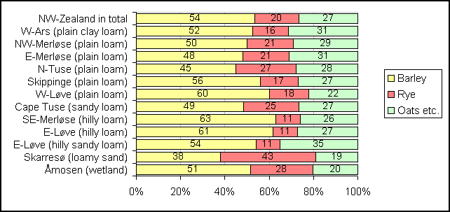
Figure
3.8. Relative crop-mix distribution of the sown acreage in twelve land-type
areas of NW-Zealand in 1662.
The major
rye-producing district of NW-Zealand in 1662 is located in the big sand-soil-dominated
area around Lake Skarresø (eastern Ars and south-western Tuse). Here, we find
an average rye percentage of 43 per cent, accompanied by the lowest barley
percentage of all the analysed areas (38 per cent). This is in good accordance
with agricultural theory, as barley historically performs its lowest yields on
sandy soils because of its high dependence of steady water supply, which is
often a problem on the easily-dried-out sand. At the same time, Danish rye is
known to give some of its best yields on the loamy sand soils of Eastern
Denmark. A perhaps more surprising observation is that also the vills around
Åmosen apparently grew quite a lot of rye (28 per cent), which has, however,
hardly taken place on the humid wetland soils, where rye performs very poorly.
The reason for the high percentage should more likely be searched in the large
sandy areas in the outskirts of the Åmosen wetlands. In fact, too much soil
water has been the major problem in Danish rye production before modern
draining techniques were implemented in the nineteenth century. When rye on
Zealand also was grown in rather large proportions on the loamy moraine soils,
it was according to several contemporary texts more out of necessity than out
of profitability; often the yields were deplorably low, but rental obligations
and the need for bread made rye an imperative part of the crop mix none the
less. This could perhaps be part of the reason that sandy soils on Zealand in
1688 were valued significantly higher than identical soils in the generally
sandy Jutland. Based on these considerations, it is a bit more difficult to
explain the low rye percentages in the region’s three areas of hilly moraine
land. The sloping terrain should in fact be expected to improve rye yields on
moraine soils due to the natural drainage, but evidently that was not the case.
The high barley-percentages in the two hilly loam areas indicate that the
ground cannot have been all that unsuited for grain in general, as secondary
crops would then be expected to cover a larger part of the sown acreage. A
possible explanation could be that moraine soils in hilly terrain often tend to
be more saturated with water than in plain terrain, partly because of dips
without outlets, partly due to an observed tendency of moraine to generate more
compact soils on high grounds in hilly terrain for reasons still not completely
clarified.
Several
foreign studies have suggested that crop mix of the past besides physical geography
was highly influenced by market-geographical conditions. While the population
in the big cities (of which Denmark only held one in this age, namely
Copenhagen) lead to a huge demand for bread grain (which for the common people
of Denmark meant rye), malt barley often became a profitable crop in the
immediate neighbourhood of medium-sized towns and export harbours. Such urban
and market-economical influences on rural production have not (yet) been
analysed systematically in NW-Zealand, but as a preliminary support for such a
connection it can pointed out that as shown in figure 3.5, four of the parishes
closest to the town of Holbæk (northern Merløse h.), and the two parishes to
the immediate east of Kalundborg (north-western Ars h.), did in fact save a
considerable part of their sown acreage (60-70 per cent) for barley.
Seed density 1662-1688
By
comparing the annual amount of seed recorded for each village in 1662 to the
sown acreage measured in 1688 (adjusted for the fallow within the two- or three-field-system),
it should, at least in theory, be possible to calculate the average seed
density used in each vill. Now of course, there is a methodical problem in
using data from two different land registers with an internal time gap of about
20 years (the actual measuring of the arable fields on Zealand for the
1688-Land Register took place in 1682). However, as it is not very likely that
the size of the arable land has changed significantly in this exact period, the
time difference is probably the least of the problems in the proposed analysis.
Earlier attempts to analyse the 1662-seed data have shown uncertainties as to
what the data actually represent, and several studies from NW-Europe have
established quite significant variations in seed density even on a regional
scale. Not only type of crops and soil conditions, but also local customs seem
to be of huge importance. Still, nothing ventured, nothing won, and so an
attempt to calculate seed densities for the acreages of NW-Zealand villages and
demesnes in 1662-88 has been performed (figure 3.9).
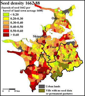
Figure
3.9. Seed density in NW-Zealand 1662-88 calculated as the recorded amount of
seed (in barrels of seed 1662) compared to the measured annual sown acreage (in
barrels of land 1688). Urban lands, vills with no seed data and permanent
pastures are not included. The bold lines represent boundaries of the medieval
hundreds.
On average,
farmers in NW-Zealand used 0.39 barrels of seed per barrel of land (bos/bol) in
1662-88. For most village vills, the seed densities lies within an interval of
0.20-0.70 bos/bol; there is a distinct tendency in the region that seed density
is higher than average on demesne acreages than it is on village acreages. The
rate level itself is somewhat surprising, as the term ‘one barrel of land’ in
the 1680s actually was defined as the average area sown by one barrel of seed
on Zealand at that time. Therefore, one would expect a level closer to 1.00
bos/bol. Identical analyses from the islands of Funen and Falster, however,
have shown seed densities of similar levels (Pedersen 1907-08, Frandsen 1983).
Here, the suggested explanations have been, that either the amount of seed
listed in 1662 was ancient figures from the late sixteenth century, or the
amount of seed used in 1662 was abnormally low due to an agricultural crisis
derived from war and Swedish occupation in 1657-60. Variations within the
interval could also reflect intra-regional differences in crop mix. In Scania,
both contemporary texts and later studies show, that rye was sown less dense
than barley and oats; especially oats was sown quite dense as to prevent weeds
from gaining too much ground (Dahl 1942). Similar tendencies of lower seed
densities in areas dominated by cultivation of rye have been found on Funen
(Frandsen 1983).
A
comparison of the seventeenth-century seed densities in NW-Zealand (figure 3.9)
with the distribution of land-value rates in 1688 (figure 3.3) will show that
there is a clear tendency towards higher seed densities on the better valued
lands. A link to soil quality also appears, when looking at the twelve
land-type areas (figure 3.10), but only between the main soil groups of
wetland, sand and moraine. Within the moraine-soil groups, the averages seem to
point in all directions.
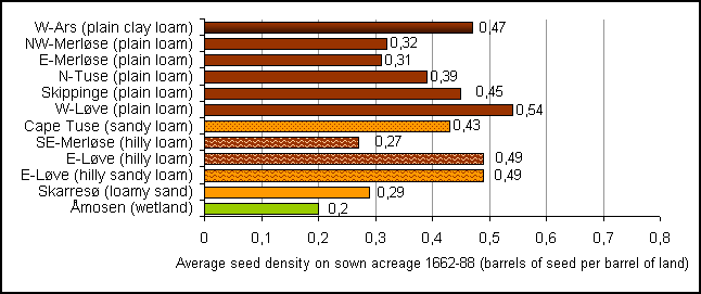
Figure 3.10. Average seed densities in twelve
land-type areas of NW-Zealand in 1662-88.
By second
look, there is, however, a quite distinct pattern also on the moraine soils of
the region regarding seventeenth-century seed density: The densities are
generally higher in the western areas than in the eastern - no matter what the
soil type and terrain type, and even on equally well-valued land. No obvious
explanation for this uneven distribution springs to mind. Surely, the sandy
rye-dominated land around Lake Skarresø does have a seed density in the low end
of the scale (0.29 bos/bol), and so it could support the findings from Funen
and Scania of a low seed density for rye, but it is no lower than the densities
found in the barley- and oats-dominated areas of Merløse (0.27-0.32 bos/bol).
The perhaps strongest indication for a relation between crop mix and seed
density is found in the hilly areas of eastern Løve, where oats could be part
of the reason for the quite high densities. Could it then be that farming
traditions altered so much between east and west within this relatively small
region?
Being
partly based in physical geography, I would, however, like to find a more
physical and measurable factor of explanation, and such a factor does indeed
emerge, when looking more closely at the soil map. Being quite alike on
soil-type distribution in general, the predominantly loamy soils of Merløse
are, as shown in figure 3.11 (right), covered with numerous tiny green dots,
indicating the presence of small spots of wetland scattered all over the area -
in hilly terrain as well as in plain. Similar green dots can also be found in
the western hundred of Løve (figure 3.11 left), but in far smaller numbers.
Supplementary analyses confirm a general tendency in the entire region towards
lower seed densities in areas with a high proportion of small wetland spots;
the soil map records such spots down to a size of approximately 50 m², but it
is most likely that several even smaller spots have existed in real life in the
same areas - in the seventeenth century, that is, as field draining has cleared
off most of them today. The reason for this difference is geo-morphological.
For some reason, the plain moraine landscape of Merløse is a bit more ‘bumpy’
or undulating than the plains of the west, and together with the thick moraine
beds below the top soil, water apparently tend to ‘get caught’ for longer
periods in many of these ‘moraine-terrain troughs’. The findings correlate with
studies from Funen, which show that in some vills only two thirds of the annual
sown acreage were actually sown in the 1680s, the rest being left for grazing
because of pure soil quality due to water, stones, clay, sand, etc.
(Porsmose 1991). It is interesting, though, that this rather distinct physical-geographical
difference between the eastern and western land-type areas of NW-Zealand only
emerges when looking at seed density, and not at all appears when looking at
arable percentages or land value.
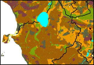
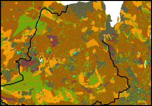
Figure
3.11. Soil maps of the main parts of Løve hundred (left) and Merløse hundred
(right). Brown colours show loamy soils, orange colours sandy soils,
light-green colour wetland soils; the dark-green colour indicates areas with no
record of soil type (mainly cities or forests). The black lines represent
boundaries of the medieval hundreds.
Production mix (arable
versus pastural) 1662
As claimed
in the opening analysis, the percentage of the vill area used for arable land
can be seen as an indicator of orientation in the rural production on arable
and/or pastural production. Another and more direct approach to analyse
production-mix variations is based on the Land Register of 1662. In this
register, the actual rent for each village farm and its distribution on the
different kinds of payment is documented. In some villages, mainly where all
village farms were owned by the same landlord, the farms could be equalized to
exactly the same size with the exact same rent. An example of this from the
region is the village of Butterup (Butterup parish, Merløse h.), where all 12
farms were owned by the neighbouring manor, all of them had an arable acreage
rated to take 4 barrels of seed, and all of them paid a rent of 16 bushels of
barley, 15 bushels of rye, 3 bushels of oats, 1 lamb, and 2 chickens. In most villages
of NW-Zealand, the picture was, however, more alternating. For some villages it
is even possible to find that while one farm was to pay practically all its
rent in grain (barley and rye), another farm in the same village mainly paid
its rent with butter or fodder. Such differences are usually related to
manorial ownership, as different manors could have different preferences for
mix of payment. Also, variations in manorial ownership could lead to different
levels of rent in the same village. The most common finding is, however, that
the farms of the individual village had a reasonable similar correlation
between rent and amount of seed (i.e. arable land), as well as a quite
homogeneous rent-payment mix. Therefore, the total rent of the village does give
a good indication of the conditions for the individual farms, and as the
average village rent-mixes also paint a rather systematic picture on the
regional scale, it seems fair to presume, that the rent-mix-distribution to a
large extent also represents the actual production. It should be emphasized,
though, that the actual percentages of various kinds in the tenancy payments
are not claimed to equal the actual percentages in the production mix. A grain
percentage of 75, for instance, does not mean that exactly 75 per cent of the
gross production value came from grain. The figures should only be used as
relative indicators of the orientation in the rural production.
In 1662,
the average tenant in NW-Zealand paid 81 per cent of his rent in grain (43 per
cent barley, 15 per cent rye, and 23 per cent oats). The remaining 19 per cent
was paid in animals, fodder and butter. As a supplement to the grain rent, most
farms gave a few lambs or poultry, which do, however, seem to have had a rather
insignificant economical importance. In vills with meadows, pastures or
forests, fodder or feeding could cover a more significant part of the rent, but
the by far most important rental type of the region in 1662 besides grain was
butter. Not all farms paid any butter at all, in fact, most farms did not, but
for those who did, the butter rent usually constituted a third or more of the
total rent.
Figure
3.12. Rent mix in NW-Zealand 1662 shown as the percentage of rent paid in grain.
Urban lands, demesnes and permanent pastures are not included. The bold lines
represent boundaries of the medieval hundreds.
The
distribution of village rent-mixes in NW-Zealand 1662 is shown in figure 3.12
as the percentage of the total rent (assessed in the standard term barrels
of hartkorn), which was based on payments in grain (i.e. barley, rye, and
oats). As the map should show, grain payments constituted more than two thirds
of the total rent in most of the village vills of the region. Especially in the
western part of the region, rent was almost exclusively paid in grain. The
lowest grain-shares, on the other hand, are found in the central and the
south-eastern districts of the region around Åmosen and to the south of Lake
Skarresø, as well as the north-eastern part of Ods.
Looking at
the twelve land-type areas of the analyses (figure 3.13), it is clear that the
rental obligations of the tenants in the plain moraine areas mainly were based
on grain. This tendency does, however, become less evident, moving from west
towards east. In the easternmost area of the group (E-Merløse), the grain
percentage is as low as in the hilly moraine areas. Probably, the variations
among the plain moraine areas have to do with the alternative possibilities of
production. In NW-Zealand, the primary alternative to grain was fodder and
butter. For a village to obtain any significant production of pastural
orientation, it was necessary to have substantial access to either meadows or
forests. Therefore, when the vills of the westernmost moraine areas along the
coast paid less than 10 per cent of their rent in non-grain products, it does
not necessarily only reflect how well-suited their soils were for arable use,
it could also reflect a lack of alternatives; ‘The Plain’, which the region
along the western coast was called, was the most deforested district of Western
Zealand by the end of the Middle Ages. In the eastern districts of the region,
the situation was quite another, and so the mere 78 per cent grain-share of the
rent in the area of eastern Merløse should probably not be taken as a prove
that this eastern moraine plain was significantly less qualified for arable
than was the western moraine plain of say western Løve, as much as the vills of
the rather late deforested eastern districts had much better access to both
meadows and forests. Likewise, many vills situated along the coast of the
Isefjord (and some parts of the Sejerø Bay) have enjoyed good access to coastal
meadows.
Figure
3.13. Relative distribution of main rental kinds (grain or non-grain) in twelve
land-type areas of NW-Zealand in 1662.
Figure
3.14. Relative distribution of non-grain rental kinds in twelve land-type areas
of NW-Zealand in 1662 (all numbers are in per cent).
It is,
however, outside the moraine areas that the non-arable payments really played
an important part in the rent of 1662. Here, there is not much difference to be
found between the sand-soil area of Lake Skarresø, dominated by woodland and
pastures, and the vills of the Åmosen area with rich access to wet meadows; 43
and 48 per cent non-arable rental payments respectively. In both areas, the
main alternative payment was given in butter (32-36 per cent), while fodder and
animals constituted about half the non-arable payments in the hilly moraine
areas (and the plain E-Merløse area); in the remaining (plain) moraine areas,
almost no butter was paid in rent at all (figure 3.14).
In Danish agricultural
history, it has been argued that the Land Register of 1688 was over-focused on
taxation of the arable land, while the non-arable production was somewhat
undervalued. By looking into the calculation lists, which the final hartkorn
taxation was based upon, is the possible to calculate the actual weight of
arable, meadows, pastures and woods in the 1688-taxation. This is,
unfortunately, quite a time-consuming task, which I have not performed for
NW-Zealand. It is, however, done for the island of Funen (Porsmose 1981) and
for Ulfborg hundred in NW-Jutland (Rømer 2000). These studies show that the
non-arable lands only constituted 6 per cent of the total hartkorn on Funen,
while it contributed with 20 per cent in Ulfborg. It is quite interesting to note, therefore, that while the geographical
and agricultural- historical conditions of NW-Zealand without doubt are closer
to the conditions of Funen than of the NW-Jutland district, the average share
of non-grain rental payment in NW-Zealand 1662 was 19 per cent - and hence much
closer to the 1688-figures of NW-Jutland. This could indicate that the
traditional claim of an undervaluing of non-arable production in the 1688-Land
Register is not at all unjust.
Figure
3.15. Relative change in hartkorn taxation from the Land Register of 1662 to
the Land Register of 1688 (as percentage of the 1662-hartkorn) for all parishes
in NW-Zealand divided into three groups based on the grain-rental percentage of
the hartkorn taxation in 1662.
I have,
however, tried to test the thesis in NW-Zealand, by looking at the actual
difference of taxations in the two land registers, and how they differ when
compared to rent-mix distributions of 1662 (figure 3.15). To my surprise, this
analysis clearly shows that parishes paying a large part of their rent in grain
in 1662 tended to experience a relative large drop in taxation level compared
to parishes more based on non-arable production. The test says nothing about
whether the non-arable lands were valued fairly in 1688 compared to their
productivity or not, but it certainly does indicate, that they did not get off
any ‘easier’ in 1688 than they did in the Land Register of 1662.
Of course,
also non-physical-geographical conditions should be taken into consideration
when looking at variations in the historical rural production. As pointed out
by Bruce Campbell, the non-arable production often held a bigger commercial
importance than did arable due to weight and transportability compared to unit
price. In this light, butter and meat for instance were much more suited for
long-distance trade, while the commercial importance of barley, rye and oats
usually was quite local. Regardless the geography, in many remote areas it
would therefore be more payable to produce butter than grain. Thus, this could
be part of the reason, why butter production on Zealand especially was
dominating around Åmosen in the remote and central parts of the island.
4. Settlement
in medieval and early modern NW-Zealand
Since the
late nineteenth century, Danish settlement history has traditionally taken its
starting point in place-name studies - especially when dealing with Iron Age
and medieval settlement structure. Based on philological elements in the names
of the settlements, combined with studies of place-name types used in
Scandinavian settlements in Normandy and England, place-name scholars have been
able to class several name types with different periods. Even though the exact
length of such periods is disputed, and probably also differs regionally
throughout Scandinavia, it is the general opinion that Danish settlements with
place-name suffixes -inge, -lev, -løse, -sted and -hēm
primarily were founded during the Iron Age (more exactly from c.200-800).
From the period, which in Denmark is referred to as Viking Age (c.800-1050),
name-suffix types as -by and -tofte are common. Special interest
must be given the suffix type -torp (which in present-day Danish usually
has changed to -drup, -rup or -strup), which is the most
common place-name type in both Denmark and Sweden (Gammeltoft & Jørgensen
2002). Periodically, the suffix has been used on new settlements from c.800
to 1500, but in Denmark, especially the period c.1000-1300 appears as
the ‘grand age of thorpes’, where it primarily has been used on new hamlets
established near old villages, and on new settlements in former wasteland. In
addition, name suffixes -tved and -with seem to go back to Iron
Age and early High Middle Ages, while the etymologically familiar name-types -holt
and -rød appear to be somewhat later (c.1100-1500). The etymology
of all four (-tved, -with, -holt and -rød)
indicates that the settlements are established in relation to clearance of
forest.
Based on the
place-name material from NW-Zealand (that is all preserved references to named
settlements from the Middle Ages and the seventeenth century), a general
picture of the settlement development in the region c.800-1350 can be
drawn as in figures 4.1-4.3. Certainly, other settlements than the ones marked
on the map have existed at the times in question, but for a general idea, the
picture given is probably not at all bad.
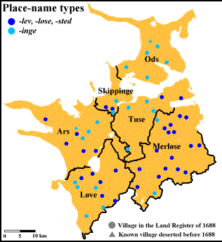
Figure
4.1-4.2. Left: Settlements in NW-Zealand by the end of the Iron Age (c.800) represented
by known villages with Iron Age name-types. Right: Settlements in NW-Zealand by
the end of the Viking Age (c.1000) represented by known villages with Iron Age
name-types and the Viking Age name-type -by. The bold lines represent
boundaries of the medieval hundreds.
Figure 4.1
represents the situation by the beginning of the Viking Age (c.800).
Cultural centres of the Iron Age concentrate in the central parts of the
western hundreds (Ars and Løve), along the southern coast of the Lammefjord,
and in the northern Merløse. Especially the western plain of the region along
the Great Belt coast indicates early settling and deforestation. Also the
remaining parts of Merløse and the central part of Ods were populated in the
Iron Age, but less densely and with several woodlands in between the
settlements. Sparsely settled areas, supposedly dominated by forest, can be
identified in the central part of the region (eastern Løve and southern Tuse)
and as an approximately 5 kilometres broad belt along a great part of the
coastline. Relative sparsely populated areas also occur in the central and
eastern parts of Merløse.
The
founding of by-settlements during the Viking Age (c.800-1000) has
for a large part taken form as a movement from already populated areas towards
the coastline (figure 4.2). This is especially evident in northern Ods and on
the south side of the Lammefjord. Moreover, an early colonization-movement can
be followed towards the central woodland areas of the region, like eastern Løve
and central Tuse.
Figure
4.3. Settlements in NW-Zealand by the end of the High Middle Ages (c.1350)
represented by known villages with the name-types -lev, -løse, -sted, -inge,
and -by, together with -torp and wood-names. The bold lines represent boundaries of the
medieval hundreds.
During the
High and Late Middle Ages, most of the region was settled with a large number
of thorpes and clearance villages (figure 4.3). New settlements were founded in
both the old habitated areas and in the woodlands. While villages with the
clearance-indicating place-name suffixes -tved and -rød mainly
are concentrated to the central parts of the region, torp-villages are
scattered all over the region, including the coastal zones. -Torp is by far
the most dominant name-type in NW-Zealand, as it constitutes 45 per cent of the
entire medieval and early modern place-name material. While the region’s tved-
and rød-settlements for a large part can be classified as clearance of
former woodland, the torp-suffix seems to have been used for both new
outlying hamlets close to the old villages and for colonial clearance
settlements.
In 1688,
the region counted 355 villages, but from older sources, another 40 medieval
villages can be accounted for (table 4.1). Most of these villages are known to
have been deserted in either the Late Middle Ages to give room for expanding
cities, or they were dissolved in the sixteenth or seventeenth centuries, as
their lands were given to expanding demesnes. A third group of deserted
medieval villages are concentrated to hilly woodlands with often rather sandy
soils. It is striking, by the way, that 32 of the 40 deserted villages are of
the place-name type -torp.
Table
4.1. The distribution of all known medieval and early modern villages in
NW-Zealand on place-name types.
|
Place-name
types |
Number of villages in the region |
Percentage of the total number of
villages |
Number of known villages deserted
before 1688 |
|
- lev |
12 |
3% |
0 |
|
- løse |
18 |
5% |
0 |
|
- sted |
1 |
0% |
0 |
|
- inge |
23 |
6% |
2 |
|
- bjerg and - høj |
17 |
4% |
0 |
|
other
terrain-names |
29 |
7% |
1 |
|
- by |
24 |
6% |
2 |
|
- torp |
179 |
45% |
32 |
|
- tved and -rød |
30 |
8% |
2 |
|
other wood-suffixes |
9 |
2% |
0 |
|
Others |
53 |
13% |
1 |
|
In total |
395 |
100% |
40 |
I have
tried to look for any variations in the soil-geographical conditions around the
villages of different place-name types (figure 4.4). Of course, working with an
area of this size, the average figures of the whole region must cover quite a
variety of tendencies, but as the analysis has been repeated for smaller
sub-areas of more homogeneous soil- and place-name conditions, some of the
findings seem to be more than a coincidence.
Figure
4.4. Average relative distribution of soil types in the vills of various
place-name types in NW-Zealand. The numbers in brackets state the number of
vills in each group.
First of
all, it can be noted, that villages of the Iron Age name-types -lev, -løse
and -sted are distinctly concentrated to the plain moraine areas,
especially where the soil type is loam. The løse-vills often also have
good availability of wetland. The remaining old name-type -inge has generally
quite different soil conditions, first of all more sandy. For the large group
of torp-vills, the soils are on average more sandy than around the older
settlements (except for the inge-villages, which are actually quite
identical to the torp-average), and this tendency is not just a result
of the many colonial torp-settlements in the woodlands and along the
coastline, as also the thorpes founded around old villages often find
themselves with more sandy soils than their potential ‘mother villages’. The
perhaps most significant finding of the analysis is the difference of soil
distribution in vills belonging to settlements with wood-indicating place-name
types. While the most sandy soil distribution is found for vills with tved-
and rød-names, the most loamy distribution belong to the group of
remaining wood-names. Perhaps this indicate that -tved and -rød
represent some of the earliest forest clearances, where it was preferred to
clear woodlands with the most light soils, because the forest here was less
dense and the virgin land easier to plough. Therefore, the least sandy
woodlands were left for the later generations - and their stronger ploughs?
Another
interesting aspect about the thorpes is that it is quite clear how thorpe settling
too has influenced on the old villages in the neighbourhood. This can be seen,
when looking at the size of the villages in the seventeenth-century land
registers. In figure 4.5, the settlement structure of NW-Zealand according to
the Land Register of 1662 is shown. In areas with only a limited amount of torp-settlements
(such as Tuse and Skippinge), the old villages are significantly larger in
number of farms than in more ‘torp-dense’ areas (as NW-Merløse). The
thorpes themselves, just as the old villages, vary quite considerably in size
within the region, but almost everywhere, they are smaller than the
neighbouring old villages. This means that a more dense settlement (in number
of villages) does not necessarily indicate a similar higher overall population,
as the village density also reflects whether the people of the area have chosen
to concentrate the settlement in large units or to spread it in several smaller
units.
Figure
4.5. Settlements in NW-Zealand classified by the number of farms recorded in
the Land Register of 1662. The thin lines represent boundaries of the vills,
the bold lines show the boundaries of the medieval hundreds.
The
regional differences of NW-Zealand torp-settling can only be partly
explained from my studies. There is a distinct tendency that the old villages
of the primary cultivated areas well-suited for arable agriculture, like
NW-Merløse (figure 4.6), did establish more thorpes than did the old villages
of, for instance, Åmosen (figure 4.7): 5 thorpes per old village in NW-Merløse
versus 2 thorpes in Åmosen, which can be explained by differences in
agricultural orientation; the more oriented on husbandry, the less need for
decentral farming units (:thorpes).
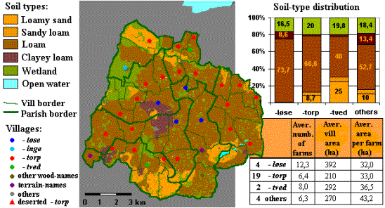
Figure
4.6. Medieval settlement structure and soil-type distribution in NW-Merløse.
Villages deserted before 1688 are not included in the calculations.
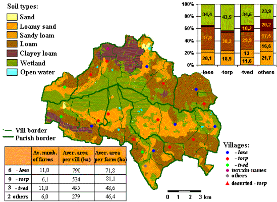
Figure
4.7. Medieval settlement structure and soil-type distribution in the Åmosen
area. Villages deserted before 1688 are not included in the calculations.
However,
this does not explain why thorpes are so relatively few in northern Tuse and
Skippinge, which geographically are areas quite alike NW-Merløse. Another
curious finding is that while torp-settlements have been used rather
frequent in the clearance of woodlands in eastern Merløse, on the capes around
Lammefjord, and on Cape Røsnæs (NW-Ars), they are quite rare in the woodlands
of south-western Ars and the central Tuse. In both cases, the explanation might
be that torp-settling - both as decentralisation and colonization -
represents a certain period, where the trend for some reason favoured decentral
settlement, while other periods have supported the larger central settlement
units. An obvious reason for such trendily shifts is changes in the political
climate, where times of war and plundering probably called for centralisation
more than decentralisation, but also different manorial policies may play an
important role. In Germany, for example, several wasteland areas given to
Benedictine abbeys or episcopal seats were colonized with lay settlers under
initiative from the new ecclesiastical owners (Mayhew 1973, 45-46). Cistercian
monasteries, on the other hand, were notorious for clearing not only wasteland,
but also already existing settlements on their new lands, which they wanted to
cultivate themselves from large grangia units (Lekai 1977, 299; Donkin
1978, 104-107). In NW-Zealand, especially lands owned by the bishop of Roskilde
(ownership mainly known from the early fourteenth century) show a richness of torp-settlements
in both arable and woodland areas above average. Several of these thorpes even
bear the names of known bishops (such as Eskilstrup). Also, the
generally torp-lacking woodland area of southern Tuse and the
southernmost part of Merløse were, as it happens, dominated by the Cistercian
abbey of Sorø (a few kilometres south of the region, cf. figure 2.1). However,
whether the Zealand bishops indeed should be seen as the ‘founding fathers’ of
many of the region’s thorpes, and the Sorø Cistercians as ‘thorpe-deserters’,
is still left to be verified.
5. Churches
and parish structures in medieval NW-Zealand
Christianity
was introduced in Denmark by the beginning of the Viking Age, and by the end of
this period (c.1050), the Danish people can be considered reasonably
christianised. From this time on and for the next two centuries, an
ecclesiastical structure of dioceses, churches, parishes, and tithes fell into
place, alongside the coming of various monastic orders. In the present chapter,
the ecclesiastical material from NW-Zealand will be analysed for information on
the economical and demographical situation of the region during the High Middle
Ages.
Age and stone material of
the medieval rural churches of NW-Zealand
The first
churches in Denmark were raised in the beginning of the ninth century, but the
major period of Danish church raising was 1050-1250. The earliest phases of
Danish church building is still rather uncertain, and even though relicts of
several wooden churches have been found under later stone buildings, the
general picture of the ecclesiastical Denmark is - except for a division in
dioceses from around 1060 - quite blurry until the beginning of the twelfth
century. By then, it became standard to build churches of stone in the local
parishes, as the parish system itself was introduced at the same time; for a
large part, the still existing parish structure was completed in the period
1150-1250.
In
NW-Zealand, 77 rural parishes were established in the High Middle Ages. To
judge from the building material and the architectural style, the majority of
these (80 per cent) had stone churches built in the twelfth century, which mean
they are classified as High Romanesque. 12 per cent of the parish churches are
classified as Late Romanesque (1200-1250), and the remaining 8 per cent as
Early Gothic (1250-1350). As seen in figure 5.1, the two younger groups of
churches are especially concentrated in the coastal areas and in an horizontal
belt going through the northern-central part of the region.
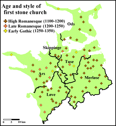
Figure
5.1. Geographical distribution of rural parish churches in medieval NW-Zealand
with indication of age and architectural style of oldest stone church. The bold
lines represent boundaries of the medieval hundreds.
Now, it
should be noted that remnants of wooden churches have been found under all
three age-groups of stone churches, so the distribution in figure 5.1 can only
with certainty show when a stone church was build, and so perhaps replacing a
wooden predecessor. Areas dominated by late stone-churches can thus be
considered either a bit later habitated, or financially weaker than the rest of
the region, at the time when it became popular to build church houses out of
stone.
Danish
parish churches from the High Romanesque period are mainly built from either
granite boulders or ashlars - or, most commonly, in a combination of the two.
In NW-Zealand, the boulders were usually used in their original form or cleaved
in two, while granite ashlars only were carved for corners and the more complex
parts of the building. Often, however, ashlars were carved in local quarries
from a more handy material, like sand stone or lime stone. In this region, the
most popular ashlar material was a calcareous tufa called frådsten (~
“foamstone”). The photograph in figure 5.2 is of one of the most famous
Romanesque churches in Denmark, Tveje Merløse (in Merløse h.), mainly known
because of its twin towers, but it is also interesting from a ‘stone
perspective’, as it is almost evenly built from the two dominating Romanesque
stone-types of the region, granite boulders and ‘foamstone’-ashlars, but in a
quite peculiar and rather illustrative way: apse, chancel, and the lower half
of the nave are built in boulders, while the upper half of the nave and the
towers are built in ashlars of calcareous tufa. The reason for this shift is
unknown, but as the ‘foamstone’ without doubt was the more prestigious material
of the two, it could appear that the building owner halfway in the project suddenly
had struck gold; perhaps in a political sense, as the great landlord of the
area, Absalon Hvide, became bishop of Zealand in 1158, which could appear to
have been the key to the foamstone-quarries. This is, however, mere
speculation. From the end of the twelfth century, bricks were introduced in the
most prestigious church-building projects, and bricks completely took over in
all levels of church building from the Early Gothic period onwards.

Figure 5.2.
The twelfth-century church of Tveje Merløse (Merløse h.), famous for its twin
towers, but also quite remarkable because of its peculiar shift in stone
material; the oldest parts (apse, chancel, and lower nave) are made of granite
boulders, the younger parts (upper nave and towers) are made of calcareous tufa
(“foamstone”). As it happens, the situation is completely the opposite in the
neighbouring and contemporary church of Nørre Jernløse; here the apse, chancel,
and lower nave are made of foamstone, the rest of the church is in granite
boulders. In both cases, the reason for the shifts is unknown.
Sizes of parishes and
churches in high medieval NW-Zealand
In
Scandinavia, there is a certain tradition for spatial studies of the medieval
parish structure. By looking at the actual shape and size of the parishes on a
regional scale, in Sweden and Norway this has led to the identification of
various layers of primary, secondary and tertiary parishes, where it is
believed that younger parish territories have been parcelled out from older
ones. In Denmark, similar attempts have generally found it very difficult to
identify an early layer of primary churches and parishes, as the establishing
of later parishes in the twelfth and thirteenth century seems to have reformed
any former structure to inrecognizability.
Spatial
studies of the medieval parish structure in Denmark have more been a matter of
the regional differences in parish sizes. On a national scale, it is quite
distinct to see how parish sizes differ with the general variations in
population density. In densely populated areas, medieval parishes are
relatively small compared to parishes in sparsely habitated areas, which is of
course no surprise, as it will take a larger area to muster enough tithe payers
to finance a church and a vicar in remote areas. Also, as the tithe was not a
fixed, but an income-dependent payment, areas of relative high agricultural
output needed fewer tithe payers per parish than what was necessary in less
fortunate areas; this tendency has been confirmed by Mats Anglert (1995) for
the medieval parishes of Scania. Here, it was also Anglert’s finding that areas
with a large number of medieval demesnes often had particularly small parishes,
which could indicate that besides demographical and economical concerns, a
political factor might have influenced the parish-forming structure, as local
landlords might have seen an interest in putting pressure on the bishop as to
raise their particular chapel into a parish church - and therefore allow for
more and smaller parishes than the economy and demography actually justified.
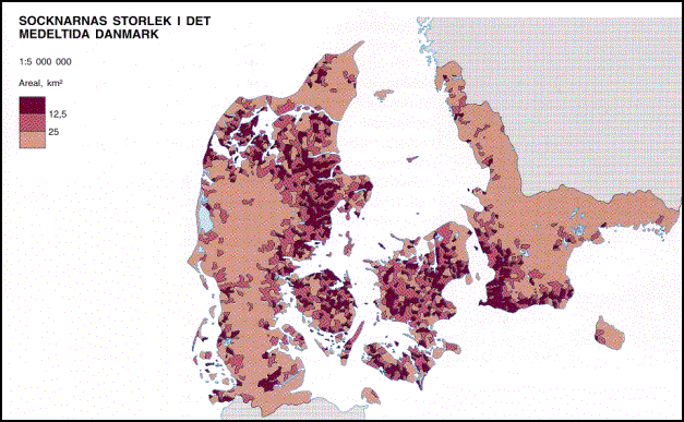
Figure
5.3. National differences of parish size in medieval Denmark; the dark colours
indicate the smallest parishes (less than 12.5 km²). (Germundsson &
Schlyter 1999, p. 65)
Figure 5.3
shows a simplified map of the variations in the size of parishes in medieval
Denmark. The map shows quite clear, how the smaller parishes and hence the
(potentially) more densely populated areas are to be found on the central
isles, in north-eastern Jutland, and in the western and southern Scania. For a
large part, this picture corresponds with the geological map, as this is also
the regions with the most fertile soils. The interdependence is especially
evident in Scania and on the islands of Zealand and Funen, where the areas of
larger parishes coincide rather accurate with less fertile soils. In Jutland,
on the other hand, the coherence is much less outspoken, as moraine soils of
south-eastern Jutland and marine clay areas along the south-western coastline
theoretically should allow for much smaller parishes than what is found, while
the soils of the north-easternmost part of the ‘small-parish’-Jutland are
actually not all that fertile. The latter combination is perhaps part of the reason
why this area in particular saw several late medieval church-closings, a
phenomenon quite unknown to late medieval Zealand.
When
working with spatial studies of parishes in medieval Denmark, it should be
pointed out that the oldest maps showing the actual boundaries of Danish
parishes are generally from the late eighteenth century, but from the written
sources, it is possible to track the early modern parish structure back to the
middle of the thirteenth century. Of course, there will occur local exceptions
of intervening changes, which - when known - can be incorporated into a
reconstructed parish map of the High Middle Ages, as for NW-Zealand in figure
5.4. And from this, the corresponding parish sizes have been calculated in
G.I.S.
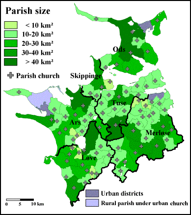
Figure
5.4. Map of high medieval parish structure of NW-Zealand with colour indication
of parish size. The bold lines represent boundaries of the medieval hundreds.
The
reconstructed medieval parish-sizes of NW-Zealand vary from 4.9 to 62.8 km²,
with the majority (74 per cent) of the parishes within an interval of 10-30
km². As seen in figure 5.4, there is a tendency of ‘clustering’ in the sense
that the individual parish is often situated among other parishes of more or
less the same size, but within the whole of the region, parish size differs
significantly - as well as rather systematically. By comparing parish-size
distribution with the previous analyses and interpretations of the
cultural-geographical history of the region, it is fair to say that areas
dominated by small parishes for a large part coincide with areas with signs of
early habitation and cultivation; for example north-western Merløse and
southern Skippinge. In the other end of the scale, we find some of the region’s
largest parishes in areas with several signs of late colonization (such as Ods
and south-eastern Merløse) or of permanent limited settlement and cultivation
(such as Åmosen in the central and south-eastern part of the region). These
findings are in accordance with the theoretical expectations mentioned above,
but - of course - one should only use such rules with a good deal of caution.
For instance, ‘The Plains’ in the western parts of Ars and Løve are expected to
be settled long before the woodland areas in the eastern parts of the same hundreds,
but still the parish sizes are considerably bigger in the west than they are in
the east. Moreover, by including the age of the stone churches, it becomes
evident that parishes with late church raising (Late Romanesque or Early
Gothic) tend to have smaller areas than other parishes in the neighbourhood.
A
complementary method in the search for relative demographical differences
between parishes of earlier times is by measuring the inside area of the part
of the church building, which is supposed to house the parishioners, namely the
nave. Admittedly, it is quite uncertain exactly how the parish churches were
used in the Middle Ages, and there are different opinions on whether it is at
all reasonable to see floor spaces of the naves as relative indicators of the
number of medieval parishioners. Attempts of such regional-comparative analyses
of Romanesque nave sizes from Western Jutland and Scania have, however, showed
rather promising results (Nyborg 1986 and Anglert 1995), and by comparing the
results of a similar analysis performed on NW-Zealand with all the other
historical-geographical analyses of the region, problems and possibilities of
the method can be further evaluated.
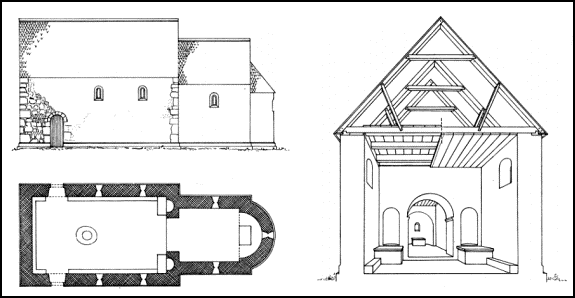
Figure
5.5. Schematic model of typical Romanesque village church in high medieval
Zealand. A model as the one in the low left corner has been reconstructed and
drawn for all Zealand parish churches with exact measures and indication of
different building periods, which is published in the work “Danmarks Kirker” (:
Churches of Denmark). Based on this, the inner nave size of all the high
medieval parish churches of the region has been estimated for the present
analysis.
The average
inner nave area of the 71 Romanesque parish churches of NW-Zealand is 73 m².
This average represents a considerable spread, as the smallest church had a
nave of just 29 m², while the largest nave of the region was about 6½ times
bigger (188 m²). For 93 per cent of the churches, however, the nave area lies
within an interval of 40-110 m², which is quite similar to the findings from
Scania. In the distribution map of figure 5.6, the Romanesque churches of
NW-Zealand are divided into three groups according to the size of the nave.
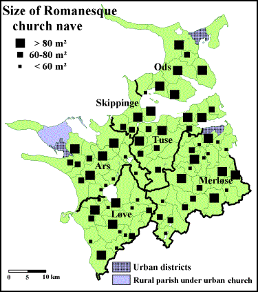
Figure 5.6.
Churches in NW-Zealand classified from the inner area of the Romanesque nave.
The thin lines show the boundaries of the medieval parishes, the bold lines
represent boundaries of the medieval hundreds. Parishes with no church symbol
did not have a stone church in the Romanesque period (1050-1250).
Geographically,
several tendencies can be observed. Small churches are especially found in the
northern Merløse, and in the central districts around Åmosen and the lakes.
There are probably two different reasons for this. Northern Merløse (especially
the north-western part) holds several signs of early settlement and dense
population in the parish-forming period, which has led to short distances
between the churches (small parishes) and relative few tithe payers per church
due to better economy for the individual farmer on average. The small and
medium-sized churches in the central districts are, however, probably more a
result of relative sparse population in the High Middle Ages; many of them are
situated rather a long way from neighbouring churches. Areas with scattered big
churches are in this region especially found in Ods and along the coastline,
which could indicate that these districts were quite recently colonized in the
twelfth century, when most of the Romanesque churches were built, but already
held a considerable population in their often rather large parishes. For all
the scattered churches in NW-Zealand, no matter what the size, there is a
tendency that they in general appear somewhat younger than the more densely
distributed churches. Finally, a group of very big churches (with naves above
100 m²) are spread all over the region, and are also found in areas with
otherwise densely packed small churches. Perhaps they represent an early layer
of baptismal churches originally covering large areas as a public supplement to
the many small private chapels; when later on more public churches were raised
and the parish structure was reformed, these old ‘minsters’ came to appear
disproportionably big.
For the
parishes in NW-Zealand with Romanesque churches, there is a distinct
correlation between the size of the parish and the inner area of the Romanesque
church nave: Big churches are mainly found in large parishes, small churches in
small parishes. This correlation is perhaps not all that surprising, but it
does constitute a problem for an attempt of using such parochial area data in a
historical-demographical context like this. If the size of the church nave
generally differs in accordance with the size of the parish, none of the two
parameters is by themselves much useful as indicators of the relative
population density of the region. The correlation of the data-sets speaks
against the possibility, that each church or each parish from the beginning has
served a (more or less) identical number of people. Thus, a small church in a
small parish can in fact reflect exactly the same population density as a big
church in a big parish. However, this analytical problem can be solved by
holding both parameters up against each other in the analysis. If the inner
area of the Romanesque parish church, as believed among most Scandinavian
scholars, does indeed reflect the size of the contemporary parish population,
it should theoretically be possible to obtain a relative expression for
population density in the twelfth century by dividing the size of the
Romanesque church nave with the total area of the high medieval parish.
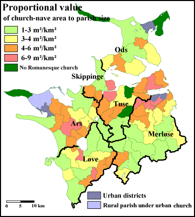
Figure
5.7. High medieval parishes in NW-Zealand classified from the proportion
between the Romanesque church nave and the total area of the parish (m² per
km²). The bold lines represent boundaries of the medieval hundreds. Parishes
coloured in dark green did not have a stone church in the Romanesque period
(1050-1250).
Such an
attempt has been performed in figure 5.7, where an area-proportional value is
calculated for each parish as the proportional between Romanesque nave size and
parish size. The individual proportional values do not say much on their own,
but by grouping them into classes and mapping their overall distribution for
the entire region as in figure 5.7, a picture appears that might indeed give a
rather plausible idea of the region’s high medieval demography. Assuming that
the concept of the method is valid, the most densely populated districts of
twelfth-century NW-Zealand are to be found around the inner shores of Holbæk
Fjord (north-western Merløse) and Lammefjord (north-western Tuse and southern
Skippinge), whereas especially the southern and the central parts of the
region, the west-coastal districts, and Ods hundred still at this time were
rather sparsely habitated. Such a use and interpretation of the available data
does not at all seem unreasonable when comparing the distribution map of figure
5.7 with other of the regional analyses performed in the survey, for instance
the extent of cultivation (arable percentages) of 1688 (figure 3.1). The main
difference between the theoretically calculated population density of the High
Middle Ages and the first indisputable quantitative expression of cultivation
is found along the Great-Belt coastline (sparsely populated in the twelfth
century, intensively cultivated in the seventeenth century), which is quite
interesting, as both the place-name material and the dating of the stone
churches too indicate a somewhat later (perhaps thirteenth-century) settlement
in these coastal districts. As it happens, the same coastal districts are also
the most predominant zones for late medieval enlargements of church naves. A
comparison of the two maps could, on the other hand, also suggest an
intervening demographical decline in south-eastern Løve and north-western Tuse.
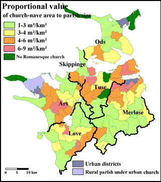
Comparison
of figure 5.7 indicating regional differences in population density in
twelfth-century NW-Zealand (as expressed by the proportional value of church
nave area to parish size), and figure 3.1 showing regional differences in
extent of cultivation (arable percentages) as recorded in the Land Register of
1688.
Churches, villages and
seigniorial seats
When the
high medieval stone churches of Denmark were built, their sites were not chosen
by random. On a very local scale, the churches in NW-Zealand were often - but
certainly not always - raised at the most elevated and visible spot in the
terrain. However, before such physical-geographical matters were considered,
parameters of a more socioeconomical type seem to have been the decisive factor
in selecting the overall position of the church on a larger geographical scale.
In NW-Zealand, the most important influencing factor on the geographical
location of parish churches appears to be the contemporary settlement, as
practically all rural parish churches of the region were built in - or very
close to - villages.
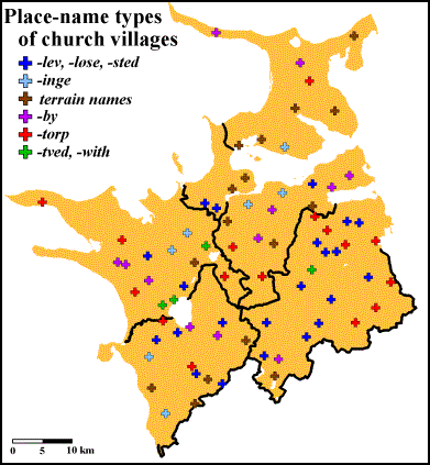
Figure
5.8. Geographical distribution of rural parish churches in medieval NW-Zealand
with indication of the place-name type of the church village. The bold lines
represent boundaries of the medieval hundreds.
38 per cent
of the 77 medieval parish churches of NW-Zealand are situated in (or at)
villages with Iron Age place-name types (-inge, -lev, -løse
and -sted). Also names in -bjerg (‘hill’) and -by are well
represented among the region’s church villages. However, the most common name
type for church villages in NW-Zealand (as for the rest of the island) is -torp
with 16 cases in the region (21 per cent of all church villages). Since -torp
also is the most common name type of the region in general, the predominance
among church villages is perhaps not all that surprising, but while torp-settlements
in general are distributed quite evenly all over the region, torp-churches
are especially predominant in Merløse, as this hundred alone holds 7 of the 16
cases.
There is a
distinct variation in the proportion of church villages among the name-types
(figure 5.9). In NW-Zealand, especially old villages with names in -lev
and -løse have attracted a lot of church raising, as about 70 per cent
of all the lev- and løse-settlements of the region also became
church villages. In districts without these Iron Age name types, the churches
tend to follow the first colonial settlements from either Viking Age (such as -by
with a church proportion of 50 per cent) or early High Middle Ages (such as -torp
and -tved with each c.10 per cent). The torp-churches of
the region are, however, not only to be regarded as a colonial phenomenon,
since several of the torp-settlements founded as outlying hamlets in
between older parent villages in the early cultivated districts too became
domicile for parish churches. Contrary to other Iron Age name types, villages in
-inge appears rather neglected as to church building with a proportion
of a mere 30 per cent, and quite often inge-villages were passed in
favour of contemporary or younger settlements in the neighbourhood. This could
indicate that by the time raising of parish churches was in its prime, the same
could not be said for inge-settlements, which by the twelfth century as
a whole seem to have experienced a less fortunate socioeconomical development
than lev- and løse-settlements. It should be noted that the ‘church
proportions’ of the place-name types in NW-Zealand are quite similar to the
situation found on the rest of Zealand and the neighbouring island of Funen.
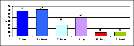
Figure
5.9. ‘Church proportion’ (i.e. proportion of church villages to all villages)
for the primary place-name types in NW-Zealand. The number of churches for each
name type is stated at the base of the columns, the church proportion (as a
percentage) above the columns.
On the
matter of distribution and location of medieval churches, several historians
have suggested the domiciles of local magnates to be of great importance. This
presumption is based on a widespread assumption among Danish historians of
today, that the majority of medieval parish churches - at least on Zealand -
were raised by the nobility. To test this thesis, I have compared the
distribution of rural parish churches with the location of known high medieval
magnates in NW-Zealand. For this analysis, seigniorial seats are defined as
places referred to in the written sources from the twelfth to the fourteenth
century (i.e. 1100-1399) as demesnes (curiæ principalis) or as homes of
a major landlord or a knight; in a few cases, archaeological findings of small
fortified castles of a high medieval character (but without any written
references) have been included as well. Based on this, I have identified 99
high medieval seigniorial seats in NW-Zealand (figure 5.10). 30 of these were
allocated in church villages, which means that only 39 per cent of the region’s
77 parish churches were raised in the immediate proximity of a known
seigniorial seat. The correlation between churches and magnates differ quite a
bit among the hundreds, where 50 per cent of the magnates in Tuse lived in a
church village, whereas the same only applied for 14 per cent of the magnates
in Ods.
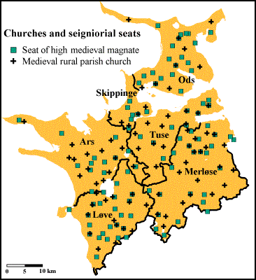
Figure
5.10. Geographical distribution of medieval parish churches and known
seigniorial seats in the High Middle Ages in NW-Zealand. The bold lines
represent boundaries of the medieval hundreds.
In regard
to the classical debate in Danish history on the question of “who built the
churches?”, it is interesting that no distinct correlation between the
distribution of parish churches and high medieval seigniorial seats can be
found in NW-Zealand, where almost two thirds of the churches were raised in
villages without any known magnate in the High Middle Ages. Of course, this
does not necessarily mean that the churches were not built on the
initiative and financial support of local magnates, but at least the analysis
suggests that the idea of landlords only building parish churches on their
private tofts probably could do with some sort of revision. However, as it will
be shown in the following analyses, the seigniorial seats and their occupants
of NW-Zealand still appear to have held an important influence in various ways
upon the raising of churches and the establishing of parochial territories.
Internal-parochial
settlement structure
Another
aspect regarding medieval churches and parishes worthwhile looking at in a
historical-geographical study like this, is the actual location of the church
within the internal settlement structure of the parish. Usually, the parish
held other settlements than the church village itself. In NW-Zealand, only four
parishes did not have any known high medieval settlements besides the church
village. On average, the rural parishes of the region held 4.7 medieval
villages, with 71 per cent of the parishes within an interval of 3-7 villages
per parish, where the high numbers especially are found in the northern and the
easternmost parts of the region.
As earlier
established, a significantly higher proportion of the villages with Iron Age
name-types has become church villages than what is found for villages of
younger name types. However, to judge from the place-name material of
NW-Zealand in combination with the medieval parochial structure, it was not
always the oldest village of the parish, which was selected parochial centre.
In 12 of the 77 rural parishes of NW-Zealand, it is possible to identify
villages with name types indicating a higher age than the related church
village. In all cases, the parish-naming village is in -by, -torp
or -with (from Viking Age or early High Middle Ages), while the in total
13 ‘passed-over’ older villages have names in -lev, -løse and -inge.
As 8 of these are inge-villages, this particular name type once again
stands out in a negative way compared to Iron Age name types in general.
By
comparing medieval church raising with the overall settlement structure within
the parish, an interesting tool is achieved for historical-geographical
analyses of high medieval demography on a local scale. This spatial method is
based on the geographical location of the church within the parish area. In
most parishes, the boundaries have been chosen in such a way that the church is
situated quite centrally, but for some parishes, the churches appear to be
situated unjustly biased compared to the distribution of the settlements, which
they are supposed to serve. Examples of both cases can be seen in figure 5.11,
where the churches of Egebjerg and Vig are quite centrally situated in their
related parishes, whereas, for example, the parishes of Vallekilde and Grevinge
have remarkably decentralized situated churches.
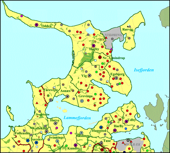
Figure
5.11. Medieval parish- and settlement map for the northern parts of NW-Zealand
(Ods, Skippinge, and Tuse hundreds with Cape Tuse).
In total,
41 of the 77 rural parishes of the region can be said to have centrally-placed
parish churches, both as to the spatial-geographical extent of the parish and
to the belonging settlement within it. For several of the parishes in this
group with only 2 or 3 villages, it can, however, be argued, that the church is
not all that centrally situated, but in all these cases, a hypothetical moving
of the church to any other of the settlements within the parish would not
improve on this (for example Asnæs parish (figure 5.11)). In the remaining 36
parishes with ‘decentrally-situated church villages’, the decentral allocation
only in a very few cases can be explained by the existence of a (known) high
medieval magnate living in the church village. In some areas, it is possible to
identify whole groups of such ‘decentral church villages’, and in most cases
there is a certain degree of systematism in the orientation of the
decentrality. An example of this from north-western Merløse is shown in figure
5.12, where it is quite distinctive, how the four churches (of the high-lighted
parishes) are closely gathered, almost as farms in a nucleated village, with
their belonging ‘fields’ (i.e. parishes) stretching out into later cultivated
and habitated areas. Note, however, that not all four (blue-coloured) løse-villages
have become church villages.
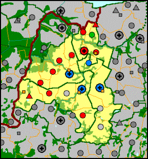
Figure
5.12. Medieval parish- and settlement map for the north-western part of Merløse
hundred, with high-light on the four parishes mentioned in the text (: Nothern
Jernløse, Southern Jernløse, Kvanløse and Søstrup).
The example
shown in figure 5.12 is by far the most striking of its kind in the region, but
less distinctive cases of ‘church-clusters’ are also to be found elsewhere in
NW-Zealand, especially in Løve hundred south of Lake Tissø. In this hundred, it
is also possible to identify two or three ‘church-belts’, with parish churches
lying in an almost straight row in the western and southern parts of the
hundred, most likely to indicate the course of contemporary arterial roads
(figure 5.13).

Figure
5.13. Medieval parish- and settlement map for the western parts of NW-Zealand
(Ars and Løve hundreds).
Further
studies of the decentrally-situated parish churches indicate that their
geographically-biased location were not necessarily equivalently unfair when
looking at the parochial demography at the time of the parish establishing. The
remote (and hence the in fact truly decentral) areas of the parish with the
longest distance to the church, very often bear several marks of late
cultivation and habitation, indicating that they only held a very sparse - if
indeed any - population at the time when the parochial borderlines fell into
place (i.e. the thirteenth century at the latest). For instance, a very
distinct and systematic decentrality of parish churches can be identified along
the coastlines, where the churches usually appear to be placed as far inland as
possible. Examples of this are the churches in Føllenslev and Vallekilde
parishes in the upper left corner of the map in figure 5.14. Another
illustrative example are the two outermost churches on Cape Tuse, Hørby and
Udby (in the upper right corner of the same map), where the church villages
almost seem to ‘curl up’ the boundaries in order to be situated further inland
than their parish territory actually justifies. The observation of such a
‘coast-derived decentrality’ for many of the region’s church villages agree
with a traditional view among Danish historians and historical geographers that
a belt of coastal woods (c.1-2 km broad) was left along the coastline of
the Danish Isles as a protecting shield for the coastal hinterland until the
thirteenth century; a hypothesis, which, although never actually proven, also
is supported by the place-name studies of the coastal settlement structure in
NW-Zealand.
Figure 5.14.
Medieval parish- and settlement map for the eastern parts of NW-Zealand
(Skippinge, Tuse and Merløse hundreds).
Also for
the central inland parishes of the region, the most probable cause for
decentrally-situated church villages seems to be an equivalently biased
settlement structure, as the remote areas of such parishes in most cases are
characterized by still existing woods or wetlands, and/or settlements with
young and even clearance- or wood-indicating place-name types. Examples of this
are the northern Sæby parish (Løve h.), the eastern Mørkøv parish (Tuse h.),
and the south-eastern Soderup parish (Merløse h.), shown in figure 5.14. In
several cases, the remote parts of such parishes with decentral churches are
adjacent to similar remote parts in neighbouring parishes, forming a
counterpart to the above-mentioned ‘church-clusters’. Indeed, I consider this
tendency to be so outspoken that I would like to promote the method of
‘parochial decentrality of churches’ as a supplementary spatial-analytic tool
for identifying areas of no or only very limited cultivation and habitation at
the time of church building and parish establishing - which in NW-Zealand for a
large part means the twelfth and the early thirteenth century.
A cognate
type of spatial studies can be performed on settlements with ‘inexpedient
parochial allocation’, that is to say settlements, which are situated closer to
a church of a neighbouring parish than to its official parish church. First, it
should be emphasized that 347 of the 395 known medieval villages in the
included 77 rural parishes of NW-Zealand were in fact parochially allocated to
the closest existing church. At the establishing of the early parochial system,
it looks as if it was an important aim to consider the interests of all the
scattered parishioners. Indeed, several at first strange-looking parish forms
begin to make sense when one also takes into consideration the distances
between the villages involved and the surrounding churches. However, for 48
villages (or 12 per cent of the material) this was not the case. A suggestion
by Danish historian Erland Porsmose (1981), that such inexpediently-allocated
villages in most cases must have come into existence after the finishing of the
parish structure, is heavily supported by the findings of NW-Zealand, as 42 of
the villages in question have name-types still in use in the thirteenth century
and later. In a few cases, inexpedient parish allocations can be explained by
features in the physical geography, such as major streams or moors situated
between the village and the nearest church, but usually the most plausible
explanation seems to be that the settlement is founded in an area, which was
not habitated until after the time, when the parochial structure had taken its
- more or less - final form (i.e. the beginning of the thirteenth century). If
originally desert woodland in the remote outskirts of the parish at a later
time was taken into use, this did not mean that the owners (or rather: the
administers) of the parish church were inclined to regulate the boundaries; in
fact, they had good financial reason not to, as more parishioners meant more
tithe. For areas with clustering of such inexpediently allocated villages in
several adjacent parishes, it should therefore be safe to argue that such areas
were not colonized before the thirteenth century at the earliest.
The
above-mentioned method should, however, only be used with some caution, as 6 of
the 48 illogically parochial-allocated villages of NW-Zealand are having Iron
Age name-types, and hence appear to be older than both the church raising and
the parish establishing. Interestingly enough, four of the villages in question
are known to have housed a high medieval magnate, and that just might be (part
of) the reason for this rather peculiar phenomenon. It is also worth noticing
that all four villages are allocated to some of the biggest churches in the
region (Ubby, Ars h.; Kundby, Tuse h.;
Hørby, Tuse h.; and Vig, Ods h.), which all have significant seigniorial
characteristics in their architecture. It is therefore my thesis that we are
dealing with churches raised in an early phase of the parochial development
(probably early twelfth century), which several of the local magnates have
found prestige in attaching themselves to; in fact, it is quite possible that
the leading families have played an important part in financing the building of
these churches. Eventually, as the forest clearance and cultivation increased
in the course of the twelfth and the thirteenth century, the more remote and
peripheral outskirts of the old parishes were habitated, and for the sake of
the churchgoing of the settlers, new and smaller parishes were established in
the colonized areas. But even though some of the magnate families now were
living closer to the new churches, they still preferred to use the old grand
church, which they had contributed to the building of and at which cemetery
their ancestors were buried - while they were probably not too keen on the
thought of turning to the new, small and poorly decorated churches of the
settlers. This is of course all mere speculations, but it is suggestive that
while all of the four parishes in question held one or more high medieval
seigniorial seats, such signs of magnates usually are lacking in the smaller
neighbouring parishes, which the old-named villages were situated closer to.
6.
Medieval economy in NW-Zealand : ‘Episcopal taxation’
While the
earlier mentioned land registers of the seventeenth century are the first
Danish economical sources of a nationwide covering, a few regional lists of
medieval origin are preserved as well. These lists are, however, far from being
straightforward documents, and the exact nature of their compilation has in
most cases been the subject of intense controversy.
An
illustrative example of this is the Roll of the Bishop of Roskilde,
especially a certain list called Parish List no. II included in this
episcopal compilation. The roll itself states that it is compiled in the 1370s,
but the list in question is undoubtedly older; exactly how old is disputed,
with various datings within the span of 1270-1320. As the name indicates, the
Parish List is a register of all the parishes in the diocese of Zealand - or at
least it was, as the first two folios with information of c.128 parishes
unfortunately are lost. For the remaining 267 parishes, the list contains three
columns, with the name of the parish in the middle, and two economical figures
in the left and the right columns. The first column solely states a figure in
the unit of either ore or marca, which are two well-known Danish
economical units of the time used on both amounts of money, quantities of
grain, and sizes of land; the proportion being 1 marca = 8 ore. Converted
to ore, all values are given in whole and even numbers, going from 2 to 16 ore
(i.e. ¼ to 2 mark), with only the value of 14 ore left out. The last column
informs of either an acreage or a quantity of seed measured in ploughs.
Table
6.1. Example of the information in Parish List no. II on two parishes in
Merløse hundred.
|
vi ore |
Myætheløsæ (Tveje Merløse) |
habet terras vnius aratri |
|
i marca |
Søstorp (Søstrup) |
habet terras ad dimidium aratrum |
As mentioned,
the first folios of the list are not preserved, which also means that the
overall headings of the columns are missing. This has caused an intense debate
among Danish scholars on what the figures are in fact all about. Today, most
will agree that the right column deals with arable land belonging to either the
vicarage (mensa) or the parish church (fabrica). More controversy
is connected to the mark/ore-figures, which will be used in this analysis, but
most likely we are dealing with some sort of parochial taxation, roughly
assessed on basis of the economical potential of the parish’s productivity. My
personal guess is that the figure represents a fixed commutation of the
bishop’s tithe, paid in either money or grain by leaseholders of the actual bishop’s
tithe; if so, Parish List no. II can be seen in close connection to the
preceding Parish List no. I, which explicitly is a register of all the
holders of the bishop’s tithe (decime episcopalis) of each parish on
Zealand; only for a minority of the parishes, the episcopal third of the tithe
were directly going to the bishop’s tabula, while the majority of the
tithes were allocated to either canons of the chapter in Roskilde or to
episcopal manors situated all over the island - or, more rarely, to local
monasteries. However, my thesis is not without its problems, and several other
valid theses are possible, and since we do not know for certain exactly what
the mark/ore-figures are representing, I will use the neutral appellation ‘episcopal
taxation’.
All the
rural parishes of NW-Zealand are included in the preserved folios of Parish
List no. II - that is to say, all the parishes existing at the time, as the
old parish of Læsøholm (Ars h.) in the sparsely habitated centre of the region
at some time between the episcopal taxation (c.1300) and the compilation
of the entire roll (1370s) was divided into the parishes of Holmstrup and
Avnsø; in the Parish List, these two parishes are therefore assessed as one.
The episcopal taxation of the 76 rural parishes in NW-Zealand differs, just as
for the rest of the island, from 2 ore to the maximum 16 ore, with a regional
average of 11.2 ore. As shown in figure 6.1, the lowest assessed parishes are
generally concentrated to the central and the southern parts of the region.
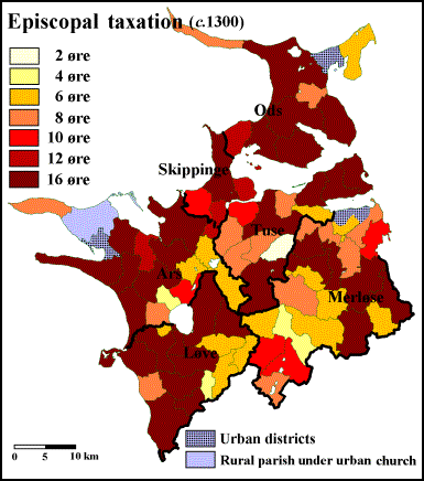
Figure
6.1. High medieval parishes in NW-Zealand classified from the ‘episcopal
taxation’ in Parish List no. II (c.1300). The bold lines represent boundaries
of the medieval hundreds.
The
episcopal taxation of the parishes in NW-Zealand did not, apparently, vary in
relation to whether the parish churches were built in High Romanesque or Late
Romanesque style. However, there is a distinct difference when looking at
parishes with Early Gothic churches, as these parishes were taxed significantly
lower than the ‘Romanesque-church parishes’ (figure 6.2). This is quite
interesting, as the period of Early Gothic church building (1250-1350) coincide
with the period in which the Parish List is thought to be compiled, and so for
the Early Gothic churches, at least, the time of the construction of the church
does appear to reflect the parochial economy.
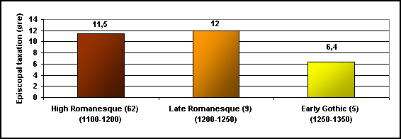
Figure
6.2. Average episcopal taxation for the parishes of NW-Zealand divided into three
groups by the dating of the parish church. The number of parishes for each
group is stated at the base of the columns, the average taxation (in ore) above
the columns.
The
differing in parish taxations cannot be explained by corresponding differences
in parish sizes only. Certainly, size did matter, as most of the parishes
larger than 20 km² also were assessed to the top rate of 16 ore, while parishes
of smaller areas generally were taxed lower. Still, if it was only a matter of
physical size, the medium-sized parishes in the western parts of the region
appear to be taxed rather high, which is also the case for several of the small
and medium-sized parishes in the eastern districts. Conversely, the central and
southern parts of the region hold several parishes of strikingly large size
compared to their taxations. Once again, a way to test the correlation between
episcopal taxation and parish size is to calculate and map the
intra-proportional values of the two parochial data sets (episcopal taxation per
km²), which should provide us with a rough idea of the regional distribution of
relative taxation - and hence the contemporary assessment of the parish’s
economical potential - by the end of the High Middle Ages.
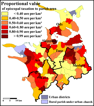
Figure
6.3. High medieval parishes in NW-Zealand classified from the proportion
between the ‘episcopal taxation’ of c.1300 and the total area of the parish
(ore per km²). The bold lines represent boundaries of the medieval hundreds.
As seen in
figure 6.3, the mapping of the proportional values between taxation and parish
size in NW-Zealand results in a rather systematic pattern. Proportionally high
taxations emerge in the north-western Merløse, on Cape Tuse (north-eastern
Tuse), in Skippinge, and in the central part of northern Ars. Due to their
minute sizes, also the small parishes to the south-west of Tissø spring to eye
with high values in this analysis. On the other hand, parishes with
proportionally low taxations are concentrated in the Åmose district of southern
Merløse and southern Tuse, the eastern parts of Løve and Ars, and in most of
Ods. Within ‘the better middle class’, we find a belt of parishes in the
western part of the region. A first conclusion from the analysis of
area-proportional taxations in NW-Zealand must therefore be that something more
than just parish size has influenced the assessment of the parishes’ capability
of paying an ecclesiastical due.
In figure
6.4, I have calculated the average level of the area-proportional episcopal
taxations within each of the 12 selected land-type areas of the region. If
indeed the area-proportional taxation can be seen as an expression of relative
land-value around 1300, then the absolute best-valued lands of the region are
found in the neighbourhood of Holbæk Town, here represented by the areas
NW-Merløse and Cape Tuse with average taxation values of 0.89 and 0.90 ore per
km². For the parishes in all the remaining land-type areas of plain loam,
average values are distributed within the span of 0.55-0.72 ore per km².
Looking solely at the group of land-type areas with loamy soils in plain
terrain, the analysis could at first indicate that the light moraine soils of
Cape Tuse were taxed significantly higher per area unit than the heavier
moraine soils of the region. However, since the medium-clayey soils of
NW-Merløse as the only ones can match the superiority of Cape Tuse’s light
moraine soils, the explanation for the distinctly higher taxations for these
two particular areas is probably to be found in the close proximity to the town
of Holbæk. One step below the areas of plain, loamy soils, we find the group of
hilly loam-lands with average levels in the interval 0.42 to 0.53 ore per km²;
this time, the lowest values are found for the parishes on the light moraine
soils of eastern Løve. Not trailing far after, the parishes of the sandy soils
around Lake Skarresø follows with an average of 0.39, while once again the peloton
is rounded off by the wetland parishes of Åmosen with a mere 0.23 ore per km².
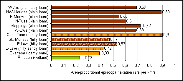
Figure
6.4. Average area-proportional episcopal taxations (episcopal taxation to total
area of parish) in twelve land-type areas of NW-Zealand c.1300.
Of course,
average values can conceal rather significant fluctuations within the material,
and for several of the land-type areas in the analysis, there are indeed quite
differing internal values, but the identified tendencies are still very strong,
when looking at how the proportional taxations of all the parishes within the
region are grouping in clusters, which I have tried to visualize in figure 6.5.
Parishes situated on moraine soils in plain terrain near the towns of Holbæk or
Kalundborg, or the episcopal castle of Dragsholm, present area-proportional
taxation values within the interval 0.90-1.10 ore per km² (or in a few cases
even more). When moving away from the urban centres (and Dragsholm Castle), the
area-proportional taxation of lands of otherwise similar natural conditions
(plain moraine) and similar cultural characteristics (early clearance and
cultivation) fall to a level of 0.60-0.80 ore per km²; such districts can be
located in western Løve, central Ars, and northern Tuse. The next level on this
potential ‘land-value scale anno 1300’ is made up of moraine-soil
parishes characterized by high medieval woodland and clearance, which in
NW-Zealand means eastern Merløse, eastern Ods, western and southern Ars, the
coastal areas along the Great Belt, and the parishes to the south of Åmosen
(southernmost Merløse and easternmost Løve). Here the proportional values differ
from 0.40 to 0.60 ore per km². In this analysis, the internal differences of
‘clayeyness’ among the moraine-soil types do not seem to matter much on the
percepted land value. On the sandy soils (Lake Skarresø area) and the hilly
moraine soils (south-eastern Merløse and eastern Løve), which still by the end
of the Middle Ages were quite dominated by woodland, the level of
area-proportional taxation values is slightly lower than for the
above-mentioned group, namely 0.35 to 0.55 ore per km². Finally, the wetland
parishes around Åmosen constitute the bottom level of the potential land-value
scale with values between 0.17 and 0.32 ore per km².
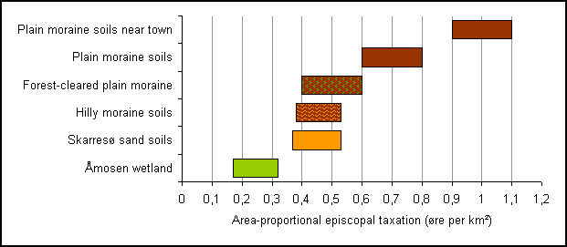
Figure
6.5. Generally applying intervals of area-proportional episcopal taxations in the
parishes of NW-Zealand divided into groups based on their natural- and
cultural-geographical conditions.
A number of
critical arguments can rightly be put forward against the analytical method
used above, especially as to the uncertainty of the included parameters (e.g.
the actual parish size, and the principle and whole nature of the ‘episcopal
taxation’), but to the advantage of the method it must be admitted that the
proportional values show a remarkably clear and systematic tendency, not least
when compared to variations in the physical geography of the parishes, and
distances to economical centres such as town markets and castles.
Economical development
c.1300 to 1688
If the
performed analyses of the episcopal taxation of c.1300 and the hartkorn taxation
in the Land Register of 1688 can be regarded as representative cross-sections
in the agro-economical situation of NW-Zealand, a comparison of the two
taxations could provide us with an idea of the intermediate development. Even
though we cannot come up with any absolute definition of the proportion between
the two taxations (How many barrels of hartkorn in 1688 corresponded with 16
ore of episcopal taxation in 1300?), we can by comparing the parish proportions
all over the region identify areas of different development. Below, this is
done rather crude by a simple visual comparison of the earlier mapped
area-proportional values of each taxation (figures 6.3 and 3.3).
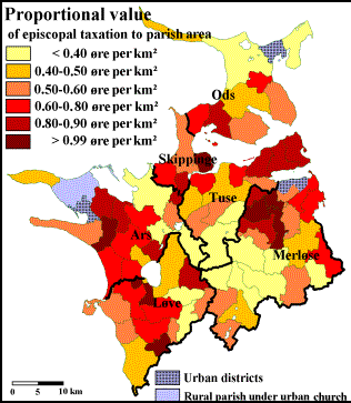
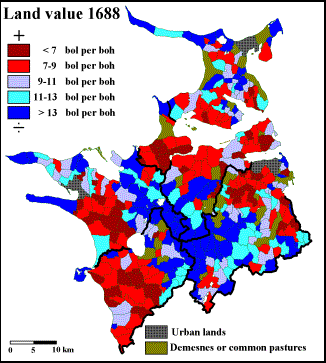
Comparison
of figure 6.3 and figure 3.3 showing regional differences in area-proportional
taxation (and hence the potential land value) in NW-Zealand c.1300 and 1688
respectively, as expressed by the ‘episcopal taxation’ in Parish List no. II
(ore per km²) and the Land Register of 1688 (barrels of land per barrels of
hartkorn); for the latter, it should be reminded that low land-value rates
indicate a high taxation.
The perhaps
most striking finding from this comparison is the similarity of the
distribution patterns - which can be taken as another plus for the validity of
the method and principles behind the medieval cross-section analysis. To a very
large extent, it is the same districts within the region that show either high
or low taxation values in c.1300 and 1688.
A more accurate
way of comparing the two cross-sections, and hereby track any potential and
systematic variation, is to calculate the proportion of the two sets of
taxation values themselves. This is done in figure 6.6, where the hartkorn
taxations of 1688 have been summed up to parish level, and then divided with
the figures of the medieval episcopal taxation. Admittedly, this is a bit like
dividing potatoes with tomatoes, and of course, the actual proportion value
itself is not very informative; the analytical merit first appears when used on
a regional-comparative level. According to the principle of the method,
parishes with relatively high proportional taxation values (barrels of hartkorn
in 1688 per ore of episcopal taxation in c.1300) have experienced more economical
growth in the intermediate period (i.e. 1300 to 1688) than parishes with
relatively low proportion values. It should be emphasized, that the proportion
values do not say anything about the absolute size of the growth or even if it
was positive or negative.
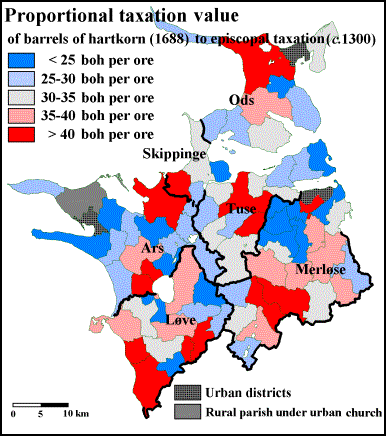
Figure
6.6. High medieval parishes in NW-Zealand classified from the proportion
between the hartkorn taxation of 1688 and the ‘episcopal taxation’ of c.1300.
The bold lines represent boundaries of the medieval hundreds.
The average
proportion value of the two taxations for the parishes in NW-Zealand is 31.4
barrels of hartkorn (boh) per ore. This average represents quite a spread, as a
few of the parishes for various reasons end up with rather extreme proportion
values, but for about 75 per cent of the parishes, the proportional taxation
values are found within the interval of 20 to 40 boh per ore. Compared to the
other analyses in the NW-Zealand project, the proportion values of the two
taxations mapped in figure 6.6 show the hitherto least notable signs of any
systematic intra-regional variation. Parishes with high potential growth rates
are scattered all over the region in pairs or small groups. The only major area
of adjoining high-valued parishes is found in the central and especially the south-western
part of Merløse, while areas of small proportional values - and hence signs of
low, none or even negative growth in the period c.1300 to 1688 - are
located in north-western Merløse, on Cape Tuse, and in large parts of Ars,
especially in the vicinity of Kalundborg.
As I will
try to show with some examples in the following, the results from this last
analysis do actually make sense, when they are carefully interpreted in
coherence with all the preceding analysis, whereas an attempt to evaluate the
economical development c.1300-1688 on this analysis alone would almost
certainly lead to highly erroneous conclusions. Some of the most systematic
findings of the region occur in the hundred of Merløse. If the analysis in
figure 6.6 does indeed say anything about the potential economical growth from c.1300
to 1688, the parishes of the north-western part of the hundred do not appear to
have reclaimed any more arable land after 1300. Thus, the extensive founding of
thorpes around the old settlement core of Iron Age-villages (figure 4.6) seems
to have taken place before the beginning of the Late Middle Ages. This
corresponds well with other findings in the survey that the demographical
density and the proportionally high taxation found in both the fourteenth and
the seventeenth centuries (figures 6.3 and 3.3) were already established in the
twelfth century (figure 5.7). In spite of the indication of low growth between c.1300
and 1688, it would be very wrong to see the north-western Merløse as an area of
late medieval crisis and decline. On the contrary, the district was throughout
the entire analysed period (c.1000-1688) among the most densely
populated, most intensively cultivated and highest taxed areas of the region,
but this position was apparently already reached at an early stage in the
Middle Ages. Based on figure 6.6, it is probably more just to speak of an
economical progress during the Late Middle Ages and/or Early Modern Times for
the central parts of Merløse, and especially for the parishes in the Åmosen
wetland district. As these areas were still rather modestly cultivated in 1688
(figures 3.1 and 3.2), the intermediate growth in taxation should most likely
find its reason in a contemporary increase in the market for pastural products.
Especially the meadows of Åmosen, which in 1662 was the centre of an extensive
butter production (figures 3.12 and 3.14), appear to have experienced a
significant increase in land value compared to the high medieval situation,
even though they still in 1688 were among the lowest taxed lands in the region
(figure 3.3)
Finally, I
will give a few examples that the blue areas of the map in figure 6.6 do not
necessarily reflect identical developments. Unlike north-western Merløse,
neither Cape Tuse nor the solitary blue enclave in the easternmost part of
Merløse (Soderup parish) give any impression of being old settlement centres.
On the contrary, both the place-name material and the church-/parish-conditions
strongly indicate that Cape Tuse was not colonized until the Viking Age, and
Soderup parish even later (figures 4.1-4.3, 5.11 and 5.14), but in both places
the development appears to have taken speed in the period 1000-1200, while the
colonization to a large part was concluded by the end of the High Middle Ages.
A completely different picture emerges in the ‘blue area’ around Lake Skarresø
in the easternmost Ars hundred. In this hitherto quite deserted woodland area
with sandy soils and in some places rather hilly terrain, there were in fact
founded a number of colonial clearance thorpes in the High Middle Ages, but
many of them were deserted again in the Late Middle Ages (figure 5.13), and
today it is still the most forest-dominated part of the region. On the sandy
plains north and north-west of Lake Skarresø, however, the high-red colours in
figure 6.6 indicate the possibility of a significant late medieval growth,
which - if indeed true - probably should find its cause in a contemporary
growth in the economical importance of rye production (figure 3.6), as the area
does not appear much oriented on pastural production by the end of the period
(figure 3.12).
Bibliography
·
Aakjær,
Svend (1926-43): Kong Valdemars Jordebog vol. 1-3, København.
·
Andresen,
Jens (2004): Jordens godhed, bondens slid, kongens skat, Geoforum Perspektiv
vol. 5, København, 44-52.
·
Anglert,
Mats (1995): Kyrkor och herravälde - Från kristnande till sockenbildning i
Skåne, Lund.
·
Anglert,
Mats (2003): Uppåkra - Bland högar, ortnamn och kyrkor, Landskapsarkeologi
och tidig medeltid - några exempel från södra Sverige, ed. by M. Anglert
& J. Thomasson, Lund, 115-144.
·
Arup, Erik
(1925): Danmarks historie vol. 1, København.
·
Berg, Johan
(2003): Gods och landskap: jordägande,
bebyggelse och samhälle i Östergötland 1000-1562, Stockholm.
·
Berglund, B.E. [ed.] (1991): The cultural landscape
during 6000 years in Southern Sweden - the Ystad Project, København.
·
Campbell, Bruce M.S. (2000): English seigniorial
agriculture, 1250-1450, Cambridge.
·
Campbell,
Åke (1928): Skånska bygder under förra hälften av 1700-talet, Uppsala.
·
Chisholm, Michael (1962): Rural
Settlement and Land Use, London.
·
Christensen,
Aksel E. (1938): Danmarks befolkning og bebyggelse i middelalderen, Befolkning
i Middelalderen, Nordisk Kultur vol. 2, ed. by J. Brøndum-Nielsen
& al., Stockholm-København-Oslo, 1-57.
·
Christensen, C.A. (1956): Roskildekirkens
Jordebøger og Regnskaber, Danske middelalderlige Regnskaber 3. series
vol. 1, København 1956, 1-207.
·
Clausen,
H.V. (1916): Studier over Danmarks Oldtidsbebyggelse, Aarbøger for nordisk Oldkyndighed
og Historie 1916,
København, 1-226.
·
la Cour,
Vilhelm (1927): Sjællands ældste Bygder - en arkæologisk-topografisk
Undersøgelse, København.
·
Dalsgaard,
Kristian (1984): Matrikelkortet fra 1844-matriklen anvendt til rekonstruktion
af det udrænede landskab, Årbøger for nordisk oldkyndighed og historie
1984, København, 282-302.
·
Dalsgaard,
Kristian (2001): Geoarkæologi i Alstrup Krat - Samspil mellem geologer og
arkæologer, Geologisk nyt 2001:1, 10-12.
·
Dalsgaard,
Kristian & al. [ed.] (2000): Mellem hav og hede - Landskab og bebyggelse
i Ulfborg herred indtil 1700, Århus.
·
Dam, Peder (2004): Landbrugsproduktivitet i tidlig moderne tid,
Roskilde.
·
Donkin,
R.A. (1978): The Cistercians: Studies in the geography of medieval England
and Wales, Toronto.
·
Erslev,
Kristian (1898): Valdemarernes Storhedstid - Studier og Omrids,
København. Fotographic reprint, København 1972.
·
Etting,
Vivian [ed.] (1995): På opdagelse i Kulturlandskabet, Århus.
·
Fabech, Charlotte & Jytte Ringtved [ed.] (1999): Settlement
and Landscape - Proceedings of a conference in Århus, Denmark, May 4-7 1998,
Højbjerg, 13-28.
·
Fabech,
Charlotte & al. (2002): Den gode jord - et natur- og kulturfænomen, Foranderlige
Landskaber, ed. by P.G. Møller & al., Odense, 112-143.
·
Frandsen,
Karl-Erik (1983): Vang og tægt, Esbjerg.
·
Frandsen,
Karl-Erik (1984): Atlas over Danmarks administrative inddeling efter 1660”,
København.
·
Franzén,
Kristina (2002): Kyrkan i landskapet, Blekinge.
Landskapets kyrkor, ed. by M. Ullén, Stockholm, 11-20; and Västergötland. Landskapets kyrkor, ed.
by M. Dahlberg, Stockholm, 13-31.
·
Fritzbøger,
Bo (1992): Danske skove 1500-1800. En landskabshistorisk undersøgelse,
Odense.
·
Gammeltoft, Peder & Bent Jørgensen [ed.] (2003): Nordiske
torp-navne. Rapport fra NORNAs 31. symposium i Jaruplund 25.-28. april 2002,
Uppsala.
·
Germundsson,
Tomas & Peter Schlyter [ed.] (1999): Atlas över Skåne, Sveriges
Nationalatlas, Uppsala.
·
Gissel,
Svend [ed.] (1977): Hornsherredundersøgelsen, med indledende metodeafsnit,
København.
·
Gissel,
Svend [ed.] (1989): Falsterundersøgelsen, Odense.
·
Greve,
Mogen H. & Poul E. Larsen (2000): Præsentation og anvendelse af digitalt
matrikelkort fra 1844 - et eksempel fra Sahl sogn, Aktører i landskabet,
ed. by P.G. Møller & al., Odense, 93-104.
·
Guttesen, Rolf (1992): New geographical and historical
information from Lucas Janz Waghenaer’s Faroe-chart, Geografisk Tidsskrift
vol. 92, 22-28.
·
Guttesen,
Rolf [ed.] (1996): Topografisk atlas Færøerne. 31 artikler med kort og
beskrivelser, København.
·
Guttesen, Rolf (2004): Food production, climate and
population in the Faroe Islands 1584-1652, Geografisk Tidsskrift vol.
104:2, København.
·
Hannerberg,
David (1955): Die älteren skandinavischen Ackermasse. Ein
Versuch zu einer zusammenfassende Theorie, Lund.
·
Hannerberg,
David (1971): Svensk agrarsamhälle under 1200 år. Gård och åker. Skörd och
boskap, Stockholm.
·
Hansen,
Carl Rise & Axel Steensberg (1951): Jordfordeling og udskiftning.
Undersøgelser i tre sjællandske landsbyer, København.
·
Hansen,
Viggo (1964): Landskab og bebyggelse i Vendsyssel : Studier over
landbebyggelsens udvikling indtil slutningen af 1600-tallet, København.
·
Hansen,
Viggo (1973): Historisk Kulturgeografi - Eksempel på arbejdsmetode med
arkivmateriale, Geografisk Orientering
1973:1, 11-17.
·
Hansen, Viggo
(1977): Geografiske variabler”, Hornsherredundersøgelsen, med indledende
metodeafsnit, ed. by S. Gissel, København, 32-35.
·
Hastrup,
Frits (1964): Danske Landsbytyper - en geografisk analyse, Århus.
·
Hatt,
Gudmund (1938): Jernalderens bopladser i Himmerland, Aarbøger for nordisk
Oldkyndighed og Historie 1938, København, 119-281.
·
Helmfrid, Staffan (1962): Östergötland “Västanstång”.
Studien über die ältere Agrarlandschaft und ihre Genese, Geografiska Annaler
vol. 44, 1-346.
·
Hoff,
Annette (1997): Lov og Landskab - Landskabslovenes bidrag til forståelsen af
landbrugs- og landskabsudviklingen i Danmark ca. 900-1250, Århus.
·
Hvass,
Steen (1984): Årtusinders landsby, Skalk 1984:3, 20-30.
·
Jansson,
Ulf (1998): Odlingssystem i Vänerområdet.
En studie av tidligmodernt jordbruk i Västsverige, Stockholm.
·
Jeppesen,
Torben Grøngaard (1979): Bebyggelsesflytninger på overgangen mellem vikingetid
og middelalder, Fra jernalder til
middelalder, ed. by H. Thrane, Odense, 99-117.
·
Korsgaard,
Peter (1988): Landsbyen og landboreformerne:
en grøn revolution i Danmark, Slagelse.
·
Korsgaard,
Peter (1995): Et par forsvundne landsbyer ved Holbæk, Fra Holbæk Amt 1995, Holbæk, 53-76.
·
Korsgaard,
Peter (2004): Videnskabernes Selskabs kort, Geoforum Perspektiv vol. 5,
København, 5-13.
·
Larsen,
Henrik (1918): Nogle Oplysninger og Bemærkninger om danske Landsbyer, Aarbøger
for nordisk Oldkyndighed og Historie 1918, København, 177-293.
·
Lauridsen,
Peter (1896): Om de gamle danske Landsbyformer, Aarbøger for nordisk
Oldkyndighed og Historie 1896, København, 97-110.
·
Lekai, Louis Julius (1977): The
Cistercians - Ideals and Reality, Kent.
·
Lerche, Grith (1994): Ploughing Implements and
Tillage Practices in Denmark from the Viking Period to About 1800, Herning.
·
Lindgren, Gunnar (1939): Falbygden och dess närmaste omgivning vid
1600-talets mitt, Geographica vol. 6, Uppsala.
·
Mathiassen,
Therkel (1959): Nordvestsjællands Oldtidsbebyggelse, Nationalmuseets
Skrifter, Arkæologisk-Historisk Række vol. 7, København.
·
Mayhew, Alan (1973): Rural
settlement and farming in Germany, London.
·
Meyer, Poul (1949): Danske bylag - En fremstilling af det danske
landsbystyre paa baggrund af retshistoriske studier over jordfællesskabets
hovedproblemer, København.
·
Müller,
Sophus (1904): Vei og Bygd i Sten- og Bronzealderen, Aarbøger for nordisk
Oldkyndighed og Historie 1904, København, 1-64.
·
Myrdal,
Janken (1985): Medeltidens åkerbruk - Agrarteknik i Sverige ca 1000 till
1520, Stockholm.
·
Myrdal,
Janken (1999): Jordbruket under feodalismen, 1000-1700, Det svenska jordbrukets
historia vol. 2, Stockholm.
·
Myrdal,
Janken & Johan Söderberg (1991): Kontinuitetens dynamik - Agrar ekonomi
i 1500-talets Sverige, Stockholm.
·
Møller, Per
Grau (1995): Højryggede agre i fynske skove, Fortid og Nutid 1995:4,
København, 303-323.
·
Møller, Per
Grau (2000): Under skoven - Bebyggelsesudvikling i en fynsk skovbygd, Mark
og menneske - Studier i Danmarks historie 1500-1800, ed. by C. Bjørn &
B. Fonnesbech-Wulff, Skårup, 11-26.
·
Møller, Per
Grau & al. [ed.] (2002): Foranderlige Landskaber, Odense.
·
Newcomb, Robert M. (1970): A model of mystery : The
medieval parish as a spatial system, Århus.
·
Newcomb, Robert M. (1975): Episodes or continuity?
: culture change on the landscape of Northeastern Jutland, Denmark,
Århus.
·
Newcomb, Robert M. (1979): Planning the past.
Historical landscape. Ressources and recreation, Studies in historical
geography, Folkestone.
·
Nielsen, Anne Birgitte (2003): Pollen based quantitative estimation of land cover : relationships
between pollen sedimentation in lakes and land cover as seen on historical maps
in Denmark AD 1800, København.
·
Nielsen,
Helge (1979): Jernalderfund og stednavnetyper, en sammenligning af fynske og
sjællandske forhold, Fra jernalder til middelalder - Beretning fra et
symposium 17.-19. maj 1979 afholdt af Odense Universitet, ed. by H. Thrane,
Odense, 87-98.
·
Nielsen,
Helge (2002): Middelalderens landbrug og arealforhold - og et forslag til
bedømmelse af agerbruget omkring fire udvalgte søområder, unpublished work
paper in the project Agrar 2000.
·
Nyborg, Ebbe
(1979): Enkeltmænd og fællesskaber i organiseringen af det romanske sognekirkebyggeri,
Strejflys over Danmarks bygningskultur - festskrift til Harald Langberg,
København, 37-64.
·
Nyborg,
Ebbe (1986): Kirke - sognedannelse - bebyggelse. Nogle overvejelser med
udgangspunkt i et bebyggelsesprojekt for Ribeområdet, hikuin vol. 12,
Højbjerg, 17-44.
·
Pedersen,
Henrik (1907-08): Udsæden og det dyrkede Areal paa Falster i sidste Halvdel af
det 17de Aarh. Nogle statistiske Bemærkninger, Historisk Tidsskrift 8. ser.
vol. 1, København, 101-137.
·
Pedersen,
Henrik (1928): De danske Landbrug -
Fremstillet paa Grundlag af Forarbejderne til Christian V’s Matrikel 1688,
København. Republished as reproprint by Landbohistorisk Selskab, København
1975.
·
Porsmose
Christensen, Erland (1977): Den stationære landsbys opståen, Kontinuitet og
bebyggelse, ed. by H. Thrane, Odense, 66-75.
·
Porsmose
Christensen, Erland (1979): Bebyggelse, kulturlandskab og driftsmåder på
overgangen mellem yngre jernalder og ældre middelalder, Fra jernalder til middelalder, ed. by H. Thrane, Odense, 118-139.
·
Porsmose,
Erland (1981): Den regulerede landsby - studier over bebyggelsesudviklingen
på Fyn i tiden fra ca. 1700 til ca. 1000 e.Kr. fødsel, Odense.
·
Porsmose,
Erland (1987): De fynske landsbyers historie - i dyrkningsfællesskabets tid,
Odense.
·
Porsmose,
Erland (1988): Middelalder o. 1000-1536, Det
danske landbrugs historie vol. 1, ed. by C. Bjørn, Odense.
·
Porsmose,
Erland (1991): Foldtal og kornproduktion, Plov og pen - Festskrift til Svend
Gissel 4. januar 1991, København, 173-196.
·
Poulsen, Bjørn (1997): Agricultural technology in
medieval Denmark, Medieval Farming and Technology - The Impact of
Agricultural Change in Northwest Europe, ed. by G. Astill & J. Langdon,
Leiden, 115-145.
·
Poulsen,
Bjørn & Anne Birgitte Sørensen (2003): Middelalderens landbrug, Det
sønderjyske landbrugs historie - Jernalder, vikingetid og middelalder, ed.
by P. Ethelberg & al., Haderslev, 375-715.
·
Poulsen, Bjørn (2004): Trade and consumption among
late medieval and early modern Danish peasants, The Scandinavian economic
history review vol. 52:1, 52-68.
·
Rasmussen,
Carsten Porskrog (2003): Rentegods og
hovedgårdsdrift : godsstrukturer og godsøkonomi i hertugdømmet Slesvig
1524-1770, Århus.
·
Riddersporre,
Mats (1995): Bymarker i backspegel : Odlingslandskapet före kartornas tid,
Lund.
·
Rømer,
Jørgen Rydén (1976): En undersøgelse af historiske marksystemer i
Centraljylland omkring slutningen af 1600-tallet på grundlag af Christian V’s
matrikel, Århus.
·
Rømer,
Jørgen Rydén (2000): Landbruget i Ulfborg herred i 1683/86, Mellem hav og
hede - Landskab og bebyggelse i Ulfborg herred indtil 1700, ed. by K.
Dalsgaard & al., Århus, 302-317.
·
Schrøder, Niels & al. (2004): 10,000 years of
climate change and human impact on the environment in the area surrounding
Lejre, The Journal of Transdisciplinary Environmental Studies 4:1,
Roskilde, 1-27.
·
Sporrong,
Ulf (1998): Landskapet format av natur och samhälle - geografins möjlighet till
forskningsintegration, Svensk
kulturgeografi, ed. by Gren & Hallin, Lund.
·
Steensberg,
Axel (1968): Atlas over Borups agre 1000-1200 e.Kr. - Textbind,
København.
·
Steensberg,
Axel & J.L. Østergaard Christensen (1974): Store Valby.
Historisk-arkæologisk undersøgelse af en nedlagt landsby på Sjælland vol.
1-3, København.
·
Steenstrup,
Johannes C.H.R. (1894-95): Nogle Bidrag til vore Landsbyers og Bebyggelsens
Historie, Historisk Tidsskrift 6. ser. vol. 5, København, 313-366.
·
Stenak,
Morten (2005): De inddæmmede landskaber :
en historisk-geografi, Odense.
·
Tollin, Clas (1999): Rågångar, gränshallar och ägoområden. Rekonstruktion av
fastighetsstruktur och bebyggelseutveckling i mellarste Småland under äldre
medeltid, Stockholm.
·
Ulsig, Erik
(1968): Danske adelsgodser i middelalderen, København.
·
Ulsig, Erik
(2001): Befolkningsfald, landgildefald og jordpriser i det 14. århundrede, Historisk
Tidsskrift vol. 101, København, 1-16.
·
Ulsig, Erik
(2004): Århusundersøgelsen - under Det nordiske Ødegårdsprojekt, Århus.
·
Widding,
Ole (1948): Markfællesskab og Landskifte, Aarbøger
for nordisk Oldkyndighed og Historie 1948,
København.
·
Widgren,
Mats (1997): Bysamfällighet och tegskifte
i Bohuslän 1300-1750, Stockholm.
·
Widgren,
Mats (2003): Röjningsröseområden på
sydsvenska höglandet : arkeologiska, kulturgeografiska och vegetationshistoriska
undersökningar, Stockholm.
·
Wienberg,
Jes (1993): Den gotiske labyrint - Middelalderen og kirkerne i Danmark,
Stockholm.